Kofçaz geodata
Kofçaz (Kırklareli) is a seat of a second-order administrative division; located in Turkey in Europe/Istanbul (GMT+3) time zone. With population of 1,647 people, there are 994 cities with bigger population in this country. Compared to other cities in Turkey, 99.6% of cities are located further ↓South; 95.9% of cities are located further →East and 63.8% of cities have higher elevation than Kofçaz. Note1


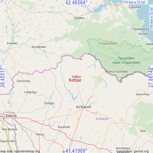
Kofçaz GPS coordinates[2]
41° 56' 41.316" North, 27° 9' 29.844" East
| Map corner | latitude | longitude |
|---|---|---|
| Upper-left | 42.46564°, | 26.45517° |
| Center: | 41.94481°, | 27.15829° |
| Lower-right: | 41.41969°, | 27.86142° |
| Map W x H: | 116.3×116.3 km | = 72.3×72.3mi |
| max Lat: | 42.02683° ⇑0.4% North |
| Kofçaz: | 41.94481° |
| min Lat: | ⇓99.6% South 35.9025° |
| min Long | Kofçaz | max Long |
| 25.90902° | 27.15829° | 44.60099° |
| W 4.1%⇐ | ⇒95.9% E |
Elevation
Elevation of Kofçaz is 439 m = 1440 ft, and this is 278.4 m = 913 ft below average elevation for this country.
| Max E: |
2682 m = 8799 ft | 63.8% |
| Avg. | 717.4 m = 2354 ft | |
| Kofçaz | 439 m = 1440 ft | |
Min E: |
0 m = 0 ft | 36.2% |
See also: Turkey elevation on elevation.city.
Geographical zone
Kofçaz is located in North temperate zone (between Tropic of Cancer and the Arctic Circle). Distance of this Northern Tropic circle is 2057.9 km =1278.7 mi to South.| Distance of | km | miles | from Kofçaz |
|---|---|---|---|
| North Pole | 5343.2 | 3320.1 | to North |
| Arctic Circle | 2737.3 | 1700.9 | to North |
| Tropic Cancer | 2057.9 | 1278.7 | to South |
| Equator | 4663.8 | 2898 | to South |


Nearby cities:
15 places around Kofçaz: (largest is in red/bold)
• Babaeski
57.2 km =35.5 mi,  185°
185°
• Dereköy
17.6 km =10.9 mi,  95°
95°
• Edirne
58.1 km =36.1 mi,  239°
239°
• Hasköy
42.2 km =26.2 mi,  216°
216°
• Havsa
52.1 km =32.4 mi,  212°
212°
• Kırklareli
24 km =14.9 mi,  166°
166°
• Lâlapaşa
36.9 km =22.9 mi,  251°
251°
• Lüleburgaz
62.4 km =38.8 mi,  164°
164°
• Pınarhisar
46.6 km =29 mi,  139°
139°
• Sergen
52.8 km =32.8 mi,  120°
120°
• Süloğlu
28.4 km =17.6 mi,  226°
226°
• Sırpsındığı
59.1 km =36.7 mi, 252°
• Yoğuntaş
14.6 km =9.1 mi, 210°
• Üsküp
31 km =19.3 mi, 138°
• İnece
30.7 km =19.1 mi, 194°
Sources, notices
• [Note1] Compared only with cities in Turkey existing in our database
• [Src1] Map data: © OpenStreetMap contributors (CC-BY-SA)
• [Src2] Other city data from geonames.org with taken over terms of usage.
• [Src3] Geographical zone / Annual Mean Temperature by Robert A. Rohde @ Wikipedia
