Lüleburgaz geodata
Lüleburgaz (Kırklareli) is a seat of a second-order administrative division; located in Turkey in Europe/Istanbul (GMT+3) time zone. With population of 90,899 people, there are 96 cities with bigger population in this country. Compared to other cities in Turkey, 96.5% of cities are located further ↓South; 94.6% of cities are located further →East and 85.1% of cities have higher elevation than Lüleburgaz. Note1


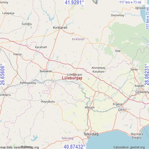
Lüleburgaz GPS coordinates[2]
41° 24' 13.86" North, 27° 21' 33.048" East
| Map corner | latitude | longitude |
|---|---|---|
| Upper-left | 41.9291°, | 26.65606° |
| Center: | 41.40385°, | 27.35918° |
| Lower-right: | 40.87432°, | 28.06231° |
| Map W x H: | 117.3×117.3 km | = 72.9×72.9mi |
| max Lat: | 42.02683° ⇑3.5% North |
| Lüleburgaz: | 41.40385° |
| min Lat: | ⇓96.5% South 35.9025° |
| min Long | Lüleburgaz | max Long |
| 25.90902° | 27.35918° | 44.60099° |
| W 5.4%⇐ | ⇒94.6% E |
Elevation
Elevation of Lüleburgaz is 71 m = 233 ft, and this is 646.4 m = 2121 ft below average elevation for this country.
| Max E: |
2682 m = 8799 ft | 85.1% |
| Avg. | 717.4 m = 2354 ft | |
| Lüleburgaz | 71 m = 233 ft | |
Min E: |
0 m = 0 ft | 14.9% |
See also: Lüleburgaz elevation on elevation.city.
Geographical zone
Lüleburgaz is located in North temperate zone (between Tropic of Cancer and the Arctic Circle). Distance of this Northern Tropic circle is 1997.8 km =1241.4 mi to South.| Distance of | km | miles | from Lüleburgaz |
|---|---|---|---|
| North Pole | 5403.4 | 3357.5 | to North |
| Arctic Circle | 2797.5 | 1738.3 | to North |
| Tropic Cancer | 1997.8 | 1241.4 | to South |
| Equator | 4603.7 | 2860.6 | to South |


Nearby cities:
15 places around Lüleburgaz: (largest is in red/bold)
• Babaeski
22.4 km =13.9 mi,  278°
278°
• Banarlı
37.5 km =23.3 mi,  182°
182°
• Beyazköy
29.4 km =18.3 mi,  102°
102°
• Büyükkarıştıran
19.3 km =12 mi,  126°
126°
• Dambaslar
22 km =13.7 mi,  204°
204°
• Hayrabolu
29.9 km =18.6 mi,  224°
224°
• Kırklareli
38.5 km =23.9 mi,  343°
343°
• Marmaracık
39.6 km =24.6 mi,  123°
123°
• Muratlı
28.3 km =17.6 mi,  155°
155°
• Pehlivanköy
36.7 km =22.8 mi,  260°
260°
• Pınarhisar
27.9 km =17.3 mi,  28°
28°
• Susuzmüsellim
41.8 km =26 mi, 215°
• Vize
38.7 km =24 mi,  61°
61°
• Üsküp
37.1 km =23.1 mi,  5°
5°
• İnece
38.9 km =24.2 mi,  321°
321°
Sources, notices
• [Note1] Compared only with cities in Turkey existing in our database
• [Src1] Map data: © OpenStreetMap contributors (CC-BY-SA)
• [Src2] Other city data from geonames.org with taken over terms of usage.
• [Src3] Geographical zone / Annual Mean Temperature by Robert A. Rohde @ Wikipedia
