Gözyeri geodata
Gözyeri (Karabük) is a populated place; located in Turkey in Europe/Istanbul (GMT+3) time zone. With population of 8,305 people, there are 565 cities with bigger population in this country. Compared to other cities in Turkey, 85.1% of cities are located further ↓South; 64.2% of cities are located further →East and 82.7% of cities have lower elevation than Gözyeri. Note1


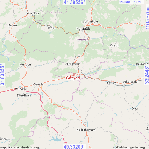
Gözyeri GPS coordinates[2]
40° 51' 57.456" North, 32° 32' 30.012" East
| Map corner | latitude | longitude |
|---|---|---|
| Upper-left | 41.39556°, | 31.83855° |
| Center: | 40.86596°, | 32.54167° |
| Lower-right: | 40.33209°, | 33.2448° |
| Map W x H: | 118.2×118.2 km | = 73.4×73.4mi |
| max Lat: | 42.02683° ⇑14.9% North |
| Gözyeri: | 40.86596° |
| min Lat: | ⇓85.1% South 35.9025° |
| min Long | Gözyeri | max Long |
| 25.90902° | 32.54167° | 44.60099° |
| W 35.8%⇐ | ⇒64.2% E |
Elevation
Elevation of Gözyeri is 1250 m = 4101 ft, and this is 532.6 m = 1747 ft above average elevation for this country.
| Max E: |
2682 m = 8799 ft | 17.3% |
| Gözyeri | 1250 m 4101 ft | |
| Avg. | 717.4 m = 2354 ft | |
Min E: |
0 m = 0 ft | 82.7% |
See also: Turkey elevation on elevation.city.
Geographical zone
Gözyeri is located in North temperate zone (between Tropic of Cancer and the Arctic Circle). Distance of this Northern Tropic circle is 1937.9 km =1204.2 mi to South.| Distance of | km | miles | from Gözyeri |
|---|---|---|---|
| North Pole | 5463.2 | 3394.7 | to North |
| Arctic Circle | 2857.3 | 1775.4 | to North |
| Tropic Cancer | 1937.9 | 1204.2 | to South |
| Equator | 4543.9 | 2823.4 | to South |


Nearby cities:
15 places around Gözyeri: (largest is in red/bold)
• Atkaracalar
45.3 km =28.1 mi,  97°
97°
• Dörtdivan
43.4 km =27 mi,  248°
248°
• Eskipazar
8.6 km =5.3 mi,  353°
353°
• Gerede
29.9 km =18.6 mi,  255°
255°
• Güvem
32.2 km =20 mi,  161°
161°
• Karabük
38.4 km =23.9 mi,  10°
10°
• Kızılcahamam
45 km =28 mi,  168°
168°
• Mengen
39.9 km =24.8 mi,  281°
281°
• Ovacık
39.5 km =24.5 mi,  53°
53°
• Pazarköy
31.1 km =19.3 mi, 282°
• Safranbolu
44.7 km =27.8 mi,  16°
16°
• Yenice
41.1 km =25.5 mi,  334°
334°
• Yeniçağa
44 km =27.3 mi, 256°
• Çamlıdere
42.2 km =26.2 mi,  187°
187°
• Çerkeş
30.2 km =18.8 mi, 101°
Sources, notices
• [Note1] Compared only with cities in Turkey existing in our database
• [Src1] Map data: © OpenStreetMap contributors (CC-BY-SA)
• [Src2] Other city data from geonames.org with taken over terms of usage.
• [Src3] Geographical zone / Annual Mean Temperature by Robert A. Rohde @ Wikipedia
