Safranbolu geodata
Safranbolu (Karabük) is a seat of a second-order administrative division; located in Turkey in Europe/Istanbul (GMT+3) time zone. With population of 35,242 people, there are 225 cities with bigger population in this country. Compared to other cities in Turkey, 95% of cities are located further ↓South; 63.4% of cities are located further →East and 60.9% of cities have higher elevation than Safranbolu. Note1


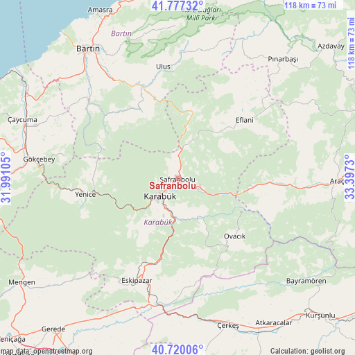
Safranbolu GPS coordinates[2]
41° 15' 2.988" North, 32° 41' 39.012" East
| Map corner | latitude | longitude |
|---|---|---|
| Upper-left | 41.77732°, | 31.99105° |
| Center: | 41.25083°, | 32.69417° |
| Lower-right: | 40.72006°, | 33.3973° |
| Map W x H: | 117.6×117.6 km | = 73.1×73.1mi |
| max Lat: | 42.02683° ⇑5% North |
| Safranbolu: | 41.25083° |
| min Lat: | ⇓95% South 35.9025° |
| min Long | Safranbolu | max Long |
| 25.90902° | 32.69417° | 44.60099° |
| W 36.6%⇐ | ⇒63.4% E |
Elevation
Elevation of Safranbolu is 494 m = 1621 ft, and this is 223.4 m = 733 ft below average elevation for this country.
| Max E: |
2682 m = 8799 ft | 60.9% |
| Avg. | 717.4 m = 2354 ft | |
| Safranbolu | 494 m = 1621 ft | |
Min E: |
0 m = 0 ft | 39.1% |
See also: Turkey elevation on elevation.city.
Geographical zone
Safranbolu is located in North temperate zone (between Tropic of Cancer and the Arctic Circle). Distance of this Northern Tropic circle is 1980.7 km =1230.7 mi to South.| Distance of | km | miles | from Safranbolu |
|---|---|---|---|
| North Pole | 5420.4 | 3368.1 | to North |
| Arctic Circle | 2814.5 | 1748.8 | to North |
| Tropic Cancer | 1980.7 | 1230.7 | to South |
| Equator | 4586.7 | 2850 | to South |


Nearby cities:
15 places around Safranbolu: (largest is in red/bold)
• Arıt
48.9 km =30.4 mi,  353°
353°
• Eflani
29.1 km =18.1 mi,  48°
48°
• Eskipazar
36.9 km =22.9 mi,  201°
201°
• Gökçebey
46.5 km =28.9 mi,  277°
277°
• Gözyeri
44.7 km =27.8 mi, 196°
• Karabük
7.6 km =4.7 mi,  227°
227°
• Kozcağız
39.7 km =24.7 mi,  310°
310°
• Kumluca
28.9 km =18 mi,  319°
319°
• Ovacuma
22.5 km =14 mi,  12°
12°
• Ovacık
27.1 km =16.8 mi,  135°
135°
• Perşembe
48.4 km =30.1 mi,  292°
292°
• Ulus
37.3 km =23.2 mi, 353°
• Yenice
30.9 km =19.2 mi,  259°
259°
• Çerkeş
51.6 km =32.1 mi,  161°
161°
• İğdir
37.1 km =23.1 mi,  94°
94°
Sources, notices
• [Note1] Compared only with cities in Turkey existing in our database
• [Src1] Map data: © OpenStreetMap contributors (CC-BY-SA)
• [Src2] Other city data from geonames.org with taken over terms of usage.
• [Src3] Geographical zone / Annual Mean Temperature by Robert A. Rohde @ Wikipedia
