Pehlivanköy geodata
Pehlivanköy (Kırklareli) is a seat of a second-order administrative division; located in Turkey in Europe/Istanbul (GMT+3) time zone. With population of 3,153 people, there are 850 cities with bigger population in this country. Compared to other cities in Turkey, 96% of cities are located further ↓South; 97.3% of cities are located further →East and 91.1% of cities have higher elevation than Pehlivanköy. Note1


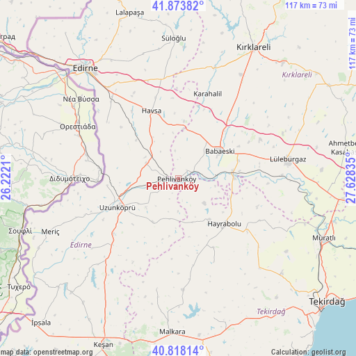
Pehlivanköy GPS coordinates[2]
41° 20' 53.232" North, 26° 55' 30.792" East
| Map corner | latitude | longitude |
|---|---|---|
| Upper-left | 41.87382°, | 26.2221° |
| Center: | 41.34812°, | 26.92522° |
| Lower-right: | 40.81814°, | 27.62835° |
| Map W x H: | 117.4×117.4 km | = 72.9×72.9mi |
| max Lat: | 42.02683° ⇑4% North |
| Pehlivanköy: | 41.34812° |
| min Lat: | ⇓96% South 35.9025° |
| min Long | Pehlivanköy | max Long |
| 25.90902° | 26.92522° | 44.60099° |
| W 2.7%⇐ | ⇒97.3% E |
Elevation
Elevation of Pehlivanköy is 33 m = 108 ft, and this is 684.4 m = 2245 ft below average elevation for this country.
| Max E: |
2682 m = 8799 ft | 91.1% |
| Avg. | 717.4 m = 2354 ft | |
| Pehlivanköy | 33 m = 108 ft | |
Min E: |
0 m = 0 ft | 8.9% |
See also: Turkey elevation on elevation.city.
Geographical zone
Pehlivanköy is located in North temperate zone (between Tropic of Cancer and the Arctic Circle). Distance of this Northern Tropic circle is 1991.6 km =1237.5 mi to South.| Distance of | km | miles | from Pehlivanköy |
|---|---|---|---|
| North Pole | 5409.6 | 3361.4 | to North |
| Arctic Circle | 2803.7 | 1742.1 | to North |
| Tropic Cancer | 1991.6 | 1237.5 | to South |
| Equator | 4597.5 | 2856.8 | to South |


Nearby cities:
15 places around Pehlivanköy: (largest is in red/bold)
• Babaeski
16.9 km =10.5 mi,  56°
56°
• Dambaslar
30.3 km =18.8 mi,  117°
117°
• Hamidiye
30.9 km =19.2 mi,  224°
224°
• Hasköy
32.7 km =20.3 mi,  350°
350°
• Havsa
23.9 km =14.9 mi,  338°
338°
• Hayrabolu
21.3 km =13.2 mi,  134°
134°
• Karakasım
30.1 km =18.7 mi,  308°
308°
• Kırcasalih
11.8 km =7.3 mi,  293°
293°
• Lüleburgaz
36.7 km =22.8 mi,  80°
80°
• Meriç
45.6 km =28.3 mi,  247°
247°
• Susuzmüsellim
30.2 km =18.8 mi,  156°
156°
• Uzunköprü
21.8 km =13.5 mi, 245°
• Çöpköy
16.6 km =10.3 mi,  210°
210°
• İnece
38.5 km =23.9 mi,  17°
17°
• Şahin
37 km =23 mi,  190°
190°
Sources, notices
• [Note1] Compared only with cities in Turkey existing in our database
• [Src1] Map data: © OpenStreetMap contributors (CC-BY-SA)
• [Src2] Other city data from geonames.org with taken over terms of usage.
• [Src3] Geographical zone / Annual Mean Temperature by Robert A. Rohde @ Wikipedia
