Karamürsel geodata
Karamürsel (Kocaeli) is a seat of a second-order administrative division; located in Turkey in Europe/Istanbul (GMT+3) time zone. With population of 30,525 people, there are 249 cities with bigger population in this country. Compared to other cities in Turkey, 80.9% of cities are located further ↓South; 78.5% of cities are located further →East and 86.6% of cities have higher elevation than Karamürsel. Note1


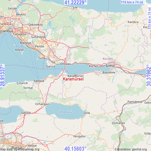
Karamürsel GPS coordinates[2]
40° 41' 28.644" North, 29° 36' 59.364" East
| Map corner | latitude | longitude |
|---|---|---|
| Upper-left | 41.22229°, | 28.91337° |
| Center: | 40.69129°, | 29.61649° |
| Lower-right: | 40.15603°, | 30.31962° |
| Map W x H: | 118.6×118.6 km | = 73.7×73.7mi |
| max Lat: | 42.02683° ⇑19.1% North |
| Karamürsel: | 40.69129° |
| min Lat: | ⇓80.9% South 35.9025° |
| min Long | Karamürsel | max Long |
| 25.90902° | 29.61649° | 44.60099° |
| W 21.5%⇐ | ⇒78.5% E |
Elevation
Elevation of Karamürsel is 62 m = 203 ft, and this is 655.4 m = 2150 ft below average elevation for this country.
| Max E: |
2682 m = 8799 ft | 86.6% |
| Avg. | 717.4 m = 2354 ft | |
| Karamürsel | 62 m = 203 ft | |
Min E: |
0 m = 0 ft | 13.4% |
See also: Turkey elevation on elevation.city.
Geographical zone
Karamürsel is located in North temperate zone (between Tropic of Cancer and the Arctic Circle). Distance of this Northern Tropic circle is 1918.5 km =1192.1 mi to South.| Distance of | km | miles | from Karamürsel |
|---|---|---|---|
| North Pole | 5482.6 | 3406.7 | to North |
| Arctic Circle | 2876.7 | 1787.5 | to North |
| Tropic Cancer | 1918.5 | 1192.1 | to South |
| Equator | 4524.4 | 2811.3 | to South |


Nearby cities:
15 places around Karamürsel: (largest is in red/bold)
• Altınova
9 km =5.6 mi,  272°
272°
• Dereköy
5.4 km =3.4 mi,  236°
236°
• Derince
18.2 km =11.3 mi,  66°
66°
• Değirmendere
14.2 km =8.8 mi,  77°
77°
• Halıdere
11.8 km =7.3 mi, 76°
• Hereke
10.5 km =6.5 mi,  359°
359°
• Kaytazdere
7.2 km =4.5 mi,  261°
261°
• Körfez
16.3 km =10.1 mi,  58°
58°
• Soğuksu
9.4 km =5.8 mi, 255°
• Tavşancıl
9.6 km =6 mi,  337°
337°
• Tavşanlı
16.7 km =10.4 mi,  328°
328°
• Taşköprü
19.1 km =11.9 mi, 264°
• Ulaşlı
6.9 km =4.3 mi, 76°
• Yalakdere
10.5 km =6.5 mi,  205°
205°
• İhsaniye
18.4 km =11.4 mi,  90°
90°
Sources, notices
• [Note1] Compared only with cities in Turkey existing in our database
• [Src1] Map data: © OpenStreetMap contributors (CC-BY-SA)
• [Src2] Other city data from geonames.org with taken over terms of usage.
• [Src3] Geographical zone / Annual Mean Temperature by Robert A. Rohde @ Wikipedia
