Yalakdere geodata
Yalakdere (Kocaeli) is a seat of a third-order administrative division; located in Turkey in Europe/Istanbul (GMT+3) time zone. With population of 2,015 people, there are 951 cities with bigger population in this country. Compared to other cities in Turkey, 79.1% of cities are located further ↓South; 78.9% of cities are located further →East and 79.4% of cities have higher elevation than Yalakdere. Note1


Yalakdere GPS coordinates[2]
40° 36' 22.896" North, 29° 33' 44.1" East
| Map corner | latitude | longitude |
|---|---|---|
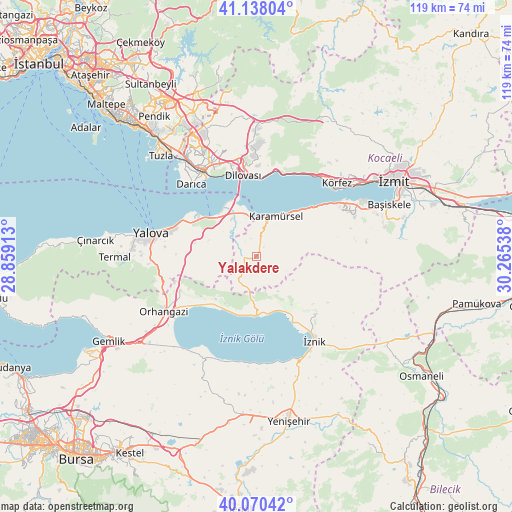
| Upper-left | 41.13804°, | 28.85913° |
| Center: | 40.60636°, | 29.56225° |
| Lower-right: | 40.07042°, | 30.26538° |
| Map W x H: | 118.7×118.7 km | = 73.8×73.8mi |
| max Lat: | 42.02683° ⇑20.9% North |
| Yalakdere: | 40.60636° |
| min Lat: | ⇓79.1% South 35.9025° |
| min Long | Yalakdere | max Long |
| 25.90902° | 29.56225° | 44.60099° |
| W 21.1%⇐ | ⇒78.9% E |
Elevation
Elevation of Yalakdere is 120 m = 394 ft, and this is 597.4 m = 1960 ft below average elevation for this country.
| Max E: |
2682 m = 8799 ft | 79.4% |
| Avg. | 717.4 m = 2354 ft | |
| Yalakdere | 120 m = 394 ft | |
Min E: |
0 m = 0 ft | 20.6% |
See also: Turkey elevation on elevation.city.
Geographical zone
Yalakdere is located in North temperate zone (between Tropic of Cancer and the Arctic Circle). Distance of this Northern Tropic circle is 1909.1 km =1186.3 mi to South.| Distance of | km | miles | from Yalakdere |
|---|---|---|---|
| North Pole | 5492.1 | 3412.6 | to North |
| Arctic Circle | 2886.2 | 1793.4 | to North |
| Tropic Cancer | 1909.1 | 1186.3 | to South |
| Equator | 4515 | 2805.5 | to South |


Nearby cities:
15 places around Yalakdere: (largest is in red/bold)
• Altınova
10.8 km =6.7 mi,  335°
335°
• Boyalıca
13.8 km =8.6 mi,  180°
180°
• Dereköy
6.4 km =4 mi,  0°
0°
• Karamürsel
10.5 km =6.5 mi,  25°
25°
• Kaytazdere
8.8 km =5.5 mi, 343°
• Kılıç
14.4 km =8.9 mi,  281°
281°
• Orhaniye
13.9 km =8.6 mi,  143°
143°
• Soğuksu
8.5 km =5.3 mi,  327°
327°
• Tacir
17.5 km =10.9 mi,  120°
120°
• Tavşancıl
18.3 km =11.4 mi, 2°
• Taşköprü
16.3 km =10.1 mi,  297°
297°
• Ulaşlı
15.8 km =9.8 mi,  45°
45°
• Çakırca
17.3 km =10.7 mi,  150°
150°
• Çakırlı
13.5 km =8.4 mi,  223°
223°
• Çukurköy
12.9 km =8 mi,  269°
269°
Sources, notices
• [Note1] Compared only with cities in Turkey existing in our database
• [Src1] Map data: © OpenStreetMap contributors (CC-BY-SA)
• [Src2] Other city data from geonames.org with taken over terms of usage.
• [Src3] Geographical zone / Annual Mean Temperature by Robert A. Rohde @ Wikipedia
