İkizce geodata
İkizce (Ordu) is a seat of a second-order administrative division; located in Turkey in Europe/Istanbul (GMT+3) time zone. With population of 10,743 people, there are 491 cities with bigger population in this country. Compared to other cities in Turkey, 91.2% of cities are located further ↓South; 57% of cities are located further ←West and 78.5% of cities have higher elevation than İkizce. Note1


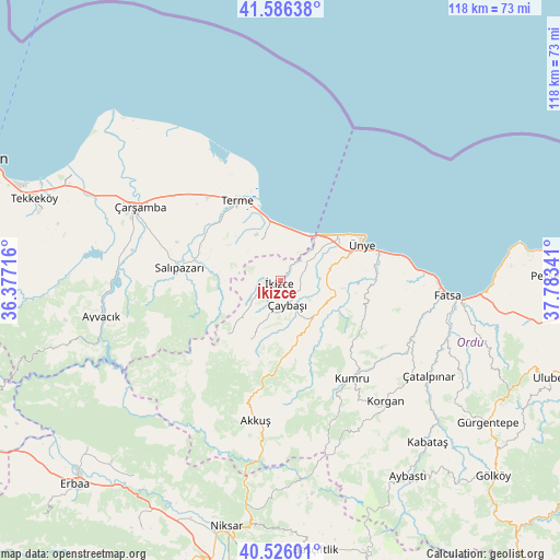
İkizce GPS coordinates[2]
41° 3' 29.988" North, 37° 4' 49.008" East
| Map corner | latitude | longitude |
|---|---|---|
| Upper-left | 41.58638°, | 36.37716° |
| Center: | 41.05833°, | 37.08028° |
| Lower-right: | 40.52601°, | 37.78341° |
| Map W x H: | 117.9×117.9 km | = 73.3×73.3mi |
| max Lat: | 42.02683° ⇑8.8% North |
| İkizce: | 41.05833° |
| min Lat: | ⇓91.2% South 35.9025° |
| min Long | İkizce | max Long |
| 25.90902° | 37.08028° | 44.60099° |
| W 57%⇐ | ⇒43% E |
Elevation
Elevation of İkizce is 132 m = 433 ft, and this is 585.4 m = 1921 ft below average elevation for this country.
| Max E: |
2682 m = 8799 ft | 78.5% |
| Avg. | 717.4 m = 2354 ft | |
| İkizce | 132 m = 433 ft | |
Min E: |
0 m = 0 ft | 21.5% |
See also: Turkey elevation on elevation.city.
Geographical zone
İkizce is located in North temperate zone (between Tropic of Cancer and the Arctic Circle). Distance of this Northern Tropic circle is 1959.3 km =1217.5 mi to South.| Distance of | km | miles | from İkizce |
|---|---|---|---|
| North Pole | 5441.8 | 3381.4 | to North |
| Arctic Circle | 2835.9 | 1762.1 | to North |
| Tropic Cancer | 1959.3 | 1217.5 | to South |
| Equator | 4565.3 | 2836.7 | to South |


Nearby cities:
15 places around İkizce: (largest is in red/bold)
• Akkuş
30 km =18.6 mi,  190°
190°
• Ayvacık
38.4 km =23.9 mi,  258°
258°
• Bolaman
43.2 km =26.8 mi,  93°
93°
• Dikbıyık
42.9 km =26.7 mi,  294°
294°
• Fatsa
35.5 km =22.1 mi,  95°
95°
• Korgan
34.3 km =21.3 mi,  139°
139°
• Kumru
25.6 km =15.9 mi, 142°
• Salıpazarı
21.1 km =13.1 mi,  277°
277°
• Tekkiraz
10.5 km =6.5 mi, 140°
• Terme
19 km =11.8 mi,  332°
332°
• Çamaş
41.4 km =25.7 mi,  114°
114°
• Çarşamba
33.8 km =21 mi,  297°
297°
• Çatalpınar
37.1 km =23.1 mi,  122°
122°
• Çaybaşı
4.8 km =3 mi,  162°
162°
• Ünye
18.8 km =11.7 mi,  64°
64°
Sources, notices
• [Note1] Compared only with cities in Turkey existing in our database
• [Src1] Map data: © OpenStreetMap contributors (CC-BY-SA)
• [Src2] Other city data from geonames.org with taken over terms of usage.
• [Src3] Geographical zone / Annual Mean Temperature by Robert A. Rohde @ Wikipedia
