Ünye geodata
Ünye (Ordu) is a seat of a second-order administrative division; located in Turkey in Europe/Istanbul (GMT+3) time zone. With population of 77,585 people, there are 116 cities with bigger population in this country. Compared to other cities in Turkey, 92.8% of cities are located further ↓South; 57.7% of cities are located further ←West and 90.2% of cities have higher elevation than Ünye. Note1


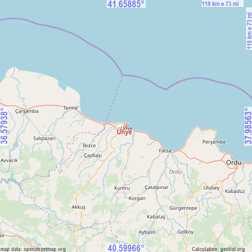
Ünye GPS coordinates[2]
41° 7' 53.004" North, 37° 16' 57" East
| Map corner | latitude | longitude |
|---|---|---|
| Upper-left | 41.65885°, | 36.57938° |
| Center: | 41.13139°, | 37.2825° |
| Lower-right: | 40.59966°, | 37.98563° |
| Map W x H: | 117.8×117.8 km | = 73.2×73.2mi |
| max Lat: | 42.02683° ⇑7.2% North |
| Ünye: | 41.13139° |
| min Lat: | ⇓92.8% South 35.9025° |
| min Long | Ünye | max Long |
| 25.90902° | 37.2825° | 44.60099° |
| W 57.7%⇐ | ⇒42.3% E |
Elevation
Elevation of Ünye is 39 m = 128 ft, and this is 678.4 m = 2226 ft below average elevation for this country.
| Max E: |
2682 m = 8799 ft | 90.2% |
| Avg. | 717.4 m = 2354 ft | |
| Ünye | 39 m = 128 ft | |
Min E: |
0 m = 0 ft | 9.8% |
See also: Ünye elevation on elevation.city.
Geographical zone
Ünye is located in North temperate zone (between Tropic of Cancer and the Arctic Circle). Distance of this Northern Tropic circle is 1967.5 km =1222.5 mi to South.| Distance of | km | miles | from Ünye |
|---|---|---|---|
| North Pole | 5433.7 | 3376.3 | to North |
| Arctic Circle | 2827.8 | 1757.1 | to North |
| Tropic Cancer | 1967.5 | 1222.5 | to South |
| Equator | 4573.4 | 2841.8 | to South |


Nearby cities:
15 places around Ünye: (largest is in red/bold)
• Akkuş
43.8 km =27.2 mi,  210°
210°
• Bolaman
28.3 km =17.6 mi,  112°
112°
• Fatsa
21.7 km =13.5 mi,  122°
122°
• Gürgentepe
46.3 km =28.8 mi,  146°
146°
• Kabataş
44.7 km =27.8 mi,  161°
161°
• Korgan
34.5 km =21.4 mi,  171°
171°
• Kumru
28.6 km =17.8 mi,  183°
183°
• Perşembe
41.6 km =25.8 mi,  100°
100°
• Salıpazarı
38.2 km =23.7 mi,  262°
262°
• Tekkiraz
19.2 km =11.9 mi, 212°
• Terme
27.2 km =16.9 mi,  288°
288°
• Çamaş
32.8 km =20.4 mi,  141°
141°
• Çatalpınar
31.5 km =19.6 mi, 152°
• Çaybaşı
20 km =12.4 mi,  230°
230°
• İkizce
18.8 km =11.7 mi,  244°
244°
Sources, notices
• [Note1] Compared only with cities in Turkey existing in our database
• [Src1] Map data: © OpenStreetMap contributors (CC-BY-SA)
• [Src2] Other city data from geonames.org with taken over terms of usage.
• [Src3] Geographical zone / Annual Mean Temperature by Robert A. Rohde @ Wikipedia
