Fatsa geodata
Fatsa (Ordu) is a seat of a second-order administrative division; located in Turkey in Europe/Istanbul (GMT+3) time zone. With population of 82,160 people, there are 111 cities with bigger population in this country. Compared to other cities in Turkey, 90.2% of cities are located further ↓South; 58.8% of cities are located further ←West and 94.8% of cities have higher elevation than Fatsa. Note1


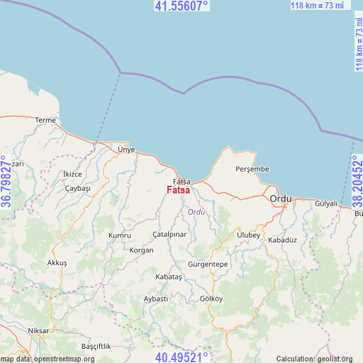
Fatsa GPS coordinates[2]
41° 1' 40.008" North, 37° 30' 5.004" East
| Map corner | latitude | longitude |
|---|---|---|
| Upper-left | 41.55607°, | 36.79827° |
| Center: | 41.02778°, | 37.50139° |
| Lower-right: | 40.49521°, | 38.20452° |
| Map W x H: | 118×118 km | = 73.3×73.3mi |
| max Lat: | 42.02683° ⇑9.8% North |
| Fatsa: | 41.02778° |
| min Lat: | ⇓90.2% South 35.9025° |
| min Long | Fatsa | max Long |
| 25.90902° | 37.50139° | 44.60099° |
| W 58.8%⇐ | ⇒41.2% E |
Elevation
Elevation of Fatsa is 17 m = 56 ft, and this is 700.4 m = 2298 ft below average elevation for this country.
| Max E: |
2682 m = 8799 ft | 94.8% |
| Avg. | 717.4 m = 2354 ft | |
| Fatsa | 17 m = 56 ft | |
Min E: |
0 m = 0 ft | 5.2% |
See also: Fatsa elevation on elevation.city.
Geographical zone
Fatsa is located in North temperate zone (between Tropic of Cancer and the Arctic Circle). Distance of this Northern Tropic circle is 1955.9 km =1215.3 mi to South.| Distance of | km | miles | from Fatsa |
|---|---|---|---|
| North Pole | 5445.2 | 3383.5 | to North |
| Arctic Circle | 2839.3 | 1764.3 | to North |
| Tropic Cancer | 1955.9 | 1215.3 | to South |
| Equator | 4561.9 | 2834.6 | to South |


Nearby cities:
15 places around Fatsa: (largest is in red/bold)
• Altınordu
31.6 km =19.6 mi,  98°
98°
• Bolaman
7.8 km =4.8 mi,  84°
84°
• Gürgentepe
27.9 km =17.3 mi,  164°
164°
• Kabataş
31.2 km =19.4 mi,  187°
187°
• Korgan
26.1 km =16.2 mi,  209°
209°
• Kumru
26.2 km =16.3 mi,  229°
229°
• Ordu
33.1 km =20.6 mi, 99°
• Perşembe
23 km =14.3 mi, 79°
• Tekkiraz
29 km =18 mi,  260°
260°
• Ulubey
27.6 km =17.1 mi,  129°
129°
• Uzunisa
31.7 km =19.7 mi,  113°
113°
• Çamaş
14.2 km =8.8 mi,  170°
170°
• Çatalpınar
17 km =10.6 mi, 193°
• Çaybaşı
33.9 km =21.1 mi,  267°
267°
• Ünye
21.7 km =13.5 mi,  302°
302°
Sources, notices
• [Note1] Compared only with cities in Turkey existing in our database
• [Src1] Map data: © OpenStreetMap contributors (CC-BY-SA)
• [Src2] Other city data from geonames.org with taken over terms of usage.
• [Src3] Geographical zone / Annual Mean Temperature by Robert A. Rohde @ Wikipedia
