Amasra geodata
Amasra (Bartın) is a seat of a second-order administrative division; located in Turkey in Europe/Istanbul (GMT+3) time zone. With population of 6,177 people, there are 650 cities with bigger population in this country. Compared to other cities in Turkey, 98.9% of cities are located further ↓South; 64.9% of cities are located further →East and 95.9% of cities have higher elevation than Amasra. Note1


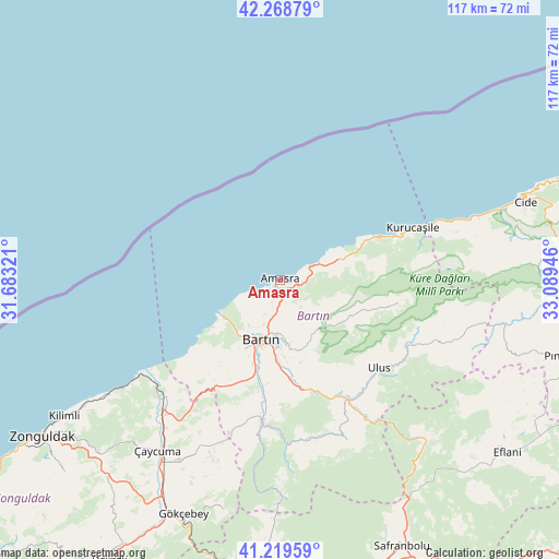
Amasra GPS coordinates[2]
41° 44' 46.788" North, 32° 23' 10.788" East
| Map corner | latitude | longitude |
|---|---|---|
| Upper-left | 42.26879°, | 31.68321° |
| Center: | 41.74633°, | 32.38633° |
| Lower-right: | 41.21959°, | 33.08946° |
| Map W x H: | 116.7×116.7 km | = 72.5×72.5mi |
| max Lat: | 42.02683° ⇑1.1% North |
| Amasra: | 41.74633° |
| min Lat: | ⇓98.9% South 35.9025° |
| min Long | Amasra | max Long |
| 25.90902° | 32.38633° | 44.60099° |
| W 35.1%⇐ | ⇒64.9% E |
Elevation
Elevation of Amasra is 14 m = 46 ft, and this is 703.4 m = 2308 ft below average elevation for this country.
| Max E: |
2682 m = 8799 ft | 95.9% |
| Avg. | 717.4 m = 2354 ft | |
| Amasra | 14 m = 46 ft | |
Min E: |
0 m = 0 ft | 4.1% |
See also: Turkey elevation on elevation.city.
Geographical zone
Amasra is located in North temperate zone (between Tropic of Cancer and the Arctic Circle). Distance of this Northern Tropic circle is 2035.8 km =1265 mi to South.| Distance of | km | miles | from Amasra |
|---|---|---|---|
| North Pole | 5365.3 | 3333.8 | to North |
| Arctic Circle | 2759.4 | 1714.6 | to North |
| Tropic Cancer | 2035.8 | 1265 | to South |
| Equator | 4641.8 | 2884.3 | to South |


Nearby cities:
15 places around Amasra: (largest is in red/bold)
• Arıt
20.8 km =12.9 mi,  108°
108°
• Bartın
12.9 km =8 mi,  198°
198°
• Beycuma
58.1 km =36.1 mi,  216°
216°
• Cide
53.7 km =33.4 mi,  72°
72°
• Filyos
36.9 km =22.9 mi,  234°
234°
• Gökçebey
53 km =32.9 mi, 202°
• Kilimli
53.6 km =33.3 mi,  238°
238°
• Kozcağız
29.6 km =18.4 mi,  188°
188°
• Kumluca
33.9 km =21.1 mi,  168°
168°
• Kurucaşile
29.2 km =18.1 mi, 69°
• Ovacuma
45 km =28 mi,  137°
137°
• Perşembe
41 km =25.5 mi,  207°
207°
• Saltukova
34.8 km =21.6 mi, 223°
• Ulus
27.8 km =17.3 mi,  130°
130°
• Çaycuma
44 km =27.3 mi, 215°
Sources, notices
• [Note1] Compared only with cities in Turkey existing in our database
• [Src1] Map data: © OpenStreetMap contributors (CC-BY-SA)
• [Src2] Other city data from geonames.org with taken over terms of usage.
• [Src3] Geographical zone / Annual Mean Temperature by Robert A. Rohde @ Wikipedia
