Bartın geodata
Bartın is a seat of a first-order administrative division; located in Turkey in Europe/Istanbul (GMT+3) time zone. With population of 37,427 people, there are 213 cities with bigger population in this country. Compared to other cities in Turkey, 98.4% of cities are located further ↓South; 65.2% of cities are located further →East and 92.2% of cities have higher elevation than Bartın. Note1


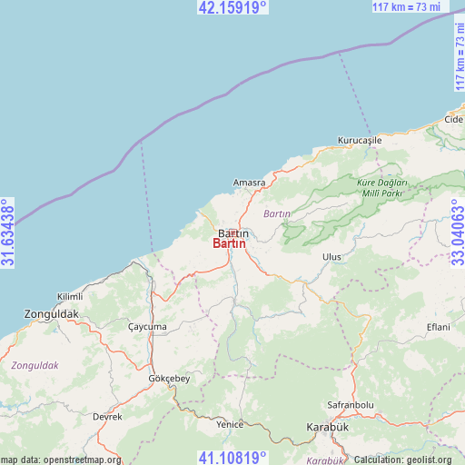
Bartın GPS coordinates[2]
41° 38' 8.988" North, 32° 20' 15" East
| Map corner | latitude | longitude |
|---|---|---|
| Upper-left | 42.15919°, | 31.63438° |
| Center: | 41.63583°, | 32.3375° |
| Lower-right: | 41.10819°, | 33.04063° |
| Map W x H: | 116.9×116.9 km | = 72.6×72.6mi |
| max Lat: | 42.02683° ⇑1.6% North |
| Bartın: | 41.63583° |
| min Lat: | ⇓98.4% South 35.9025° |
| min Long | Bartın | max Long |
| 25.90902° | 32.3375° | 44.60099° |
| W 34.8%⇐ | ⇒65.2% E |
Elevation
Elevation of Bartın is 28 m = 92 ft, and this is 689.4 m = 2262 ft below average elevation for this country.
| Max E: |
2682 m = 8799 ft | 92.2% |
| Avg. | 717.4 m = 2354 ft | |
| Bartın | 28 m = 92 ft | |
Min E: |
0 m = 0 ft | 7.8% |
See also: Turkey elevation on elevation.city.
Geographical zone
Bartın is located in North temperate zone (between Tropic of Cancer and the Arctic Circle). Distance of this Northern Tropic circle is 2023.6 km =1257.4 mi to South.| Distance of | km | miles | from Bartın |
|---|---|---|---|
| North Pole | 5377.6 | 3341.5 | to North |
| Arctic Circle | 2771.7 | 1722.3 | to North |
| Tropic Cancer | 2023.6 | 1257.4 | to South |
| Equator | 4629.5 | 2876.6 | to South |


Nearby cities:
15 places around Bartın: (largest is in red/bold)
• Amasra
12.9 km =8 mi,  18°
18°
• Arıt
24.5 km =15.2 mi,  76°
76°
• Beycuma
46 km =28.6 mi,  221°
221°
• Filyos
27.6 km =17.1 mi,  250°
250°
• Gökçebey
40.1 km =24.9 mi,  203°
203°
• Kilimli
44.5 km =27.7 mi, 248°
• Kozcağız
17 km =10.6 mi,  181°
181°
• Kumluca
23.6 km =14.7 mi,  152°
152°
• Kurucaşile
38.6 km =24 mi,  54°
54°
• Ovacuma
40.4 km =25.1 mi,  121°
121°
• Perşembe
28.3 km =17.6 mi,  211°
211°
• Saltukova
23.8 km =14.8 mi,  237°
237°
• Ulus
25.9 km =16.1 mi,  102°
102°
• Yenice
48.5 km =30.1 mi, 180°
• Çaycuma
31.9 km =19.8 mi, 223°
Sources, notices
• [Note1] Compared only with cities in Turkey existing in our database
• [Src1] Map data: © OpenStreetMap contributors (CC-BY-SA)
• [Src2] Other city data from geonames.org with taken over terms of usage.
• [Src3] Geographical zone / Annual Mean Temperature by Robert A. Rohde @ Wikipedia
