Yeniçağa geodata
Yeniçağa (Bolu) is a seat of a second-order administrative division; located in Turkey in Europe/Istanbul (GMT+3) time zone. With population of 6,852 people, there are 617 cities with bigger population in this country. Compared to other cities in Turkey, 82.9% of cities are located further ↓South; 66.5% of cities are located further →East and 68.3% of cities have lower elevation than Yeniçağa. Note1


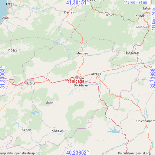
Yeniçağa GPS coordinates[2]
40° 46' 16.14" North, 32° 2' 1.5" East
| Map corner | latitude | longitude |
|---|---|---|
| Upper-left | 41.30151°, | 31.33063° |
| Center: | 40.77115°, | 32.03375° |
| Lower-right: | 40.23652°, | 32.73688° |
| Map W x H: | 118.4×118.4 km | = 73.6×73.6mi |
| max Lat: | 42.02683° ⇑17.1% North |
| Yeniçağa: | 40.77115° |
| min Lat: | ⇓82.9% South 35.9025° |
| min Long | Yeniçağa | max Long |
| 25.90902° | 32.03375° | 44.60099° |
| W 33.5%⇐ | ⇒66.5% E |
Elevation
Elevation of Yeniçağa is 1005 m = 3297 ft, and this is 287.6 m = 944 ft above average elevation for this country.
| Max E: |
2682 m = 8799 ft | 31.7% |
| Yeniçağa | 1005 m 3297 ft | |
| Avg. | 717.4 m = 2354 ft | |
Min E: |
0 m = 0 ft | 68.3% |
See also: Turkey elevation on elevation.city.
Geographical zone
Yeniçağa is located in North temperate zone (between Tropic of Cancer and the Arctic Circle). Distance of this Northern Tropic circle is 1927.4 km =1197.6 mi to South.| Distance of | km | miles | from Yeniçağa |
|---|---|---|---|
| North Pole | 5473.7 | 3401.2 | to North |
| Arctic Circle | 2867.8 | 1782 | to North |
| Tropic Cancer | 1927.4 | 1197.6 | to South |
| Equator | 4533.3 | 2816.9 | to South |


Nearby cities:
15 places around Yeniçağa: (largest is in red/bold)
• Bolu
36.2 km =22.5 mi,  263°
263°
• Devrek
50.2 km =31.2 mi,  352°
352°
• Dörtdivan
6.1 km =3.8 mi,  156°
156°
• Eskipazar
46 km =28.6 mi,  65°
65°
• Eğerci
40.8 km =25.4 mi,  333°
333°
• Gerede
14.1 km =8.8 mi,  76°
76°
• Gökçesu
15 km =9.3 mi,  335°
335°
• Gözyeri
44 km =27.3 mi, 76°
• Karaşar
49.7 km =30.9 mi,  184°
184°
• Kıbrıscık
43.2 km =26.8 mi,  200°
200°
• Mengen
19 km =11.8 mi,  10°
10°
• Pazarköy
21.2 km =13.2 mi,  35°
35°
• Peçenek
45.5 km =28.3 mi,  149°
149°
• Yenice
53.8 km =33.4 mi,  27°
27°
• Çamlıdere
48.6 km =30.2 mi,  130°
130°
Sources, notices
• [Note1] Compared only with cities in Turkey existing in our database
• [Src1] Map data: © OpenStreetMap contributors (CC-BY-SA)
• [Src2] Other city data from geonames.org with taken over terms of usage.
• [Src3] Geographical zone / Annual Mean Temperature by Robert A. Rohde @ Wikipedia
