Gökçesu geodata
Gökçesu (Bolu) is a seat of a third-order administrative division; located in Turkey in Europe/Istanbul (GMT+3) time zone. In our database, there are 1323 cities with bigger population. Compared to other cities in Turkey, 86.1% of cities are located further ↓South; 66.8% of cities are located further →East and 58.4% of cities have higher elevation than Gökçesu. Note1


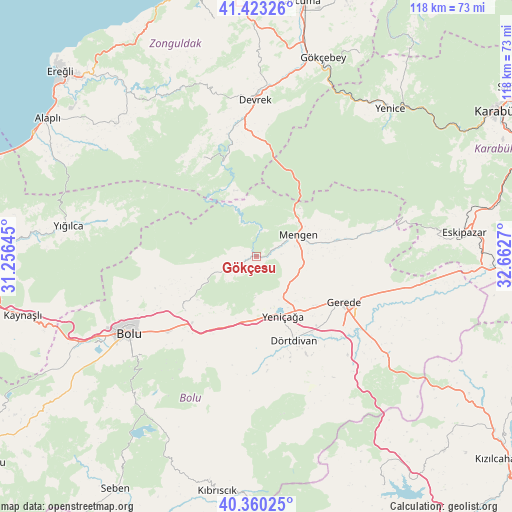
Gökçesu GPS coordinates[2]
40° 53' 38.004" North, 31° 57' 34.452" East
| Map corner | latitude | longitude |
|---|---|---|
| Upper-left | 41.42326°, | 31.25645° |
| Center: | 40.89389°, | 31.95957° |
| Lower-right: | 40.36025°, | 32.6627° |
| Map W x H: | 118.2×118.2 km | = 73.4×73.4mi |
| max Lat: | 42.02683° ⇑13.9% North |
| Gökçesu: | 40.89389° |
| min Lat: | ⇓86.1% South 35.9025° |
| min Long | Gökçesu | max Long |
| 25.90902° | 31.95957° | 44.60099° |
| W 33.2%⇐ | ⇒66.8% E |
Elevation
Elevation of Gökçesu is 528 m = 1732 ft, and this is 189.4 m = 621 ft below average elevation for this country.
| Max E: |
2682 m = 8799 ft | 58.4% |
| Avg. | 717.4 m = 2354 ft | |
| Gökçesu | 528 m = 1732 ft | |
Min E: |
0 m = 0 ft | 41.6% |
See also: Turkey elevation on elevation.city.
Geographical zone
Gökçesu is located in North temperate zone (between Tropic of Cancer and the Arctic Circle). Distance of this Northern Tropic circle is 1941.1 km =1206.1 mi to South.| Distance of | km | miles | from Gökçesu |
|---|---|---|---|
| North Pole | 5460.1 | 3392.7 | to North |
| Arctic Circle | 2854.2 | 1773.5 | to North |
| Tropic Cancer | 1941.1 | 1206.1 | to South |
| Equator | 4547 | 2825.4 | to South |


Nearby cities:
15 places around Gökçesu: (largest is in red/bold)
• Beycuma
48.3 km =30 mi,  0°
0°
• Bolu
34.5 km =21.4 mi,  239°
239°
• Devrek
36.2 km =22.5 mi,  359°
359°
• Dörtdivan
21.2 km =13.2 mi,  155°
155°
• Eskipazar
48.3 km =30 mi,  83°
83°
• Eğerci
25.8 km =16 mi,  332°
332°
• Gerede
22.5 km =14 mi,  117°
117°
• Gökçebey
48.3 km =30 mi,  18°
18°
• Gözyeri
49 km =30.4 mi,  93°
93°
• Mengen
11 km =6.8 mi,  63°
63°
• Ormanlı
41.8 km =26 mi,  316°
316°
• Pazarköy
18.9 km =11.7 mi, 79°
• Yenice
46.1 km =28.6 mi,  42°
42°
• Yeniçağa
15 km =9.3 mi, 155°
• Yığılca
44 km =27.3 mi,  279°
279°
Sources, notices
• [Note1] Compared only with cities in Turkey existing in our database
• [Src1] Map data: © OpenStreetMap contributors (CC-BY-SA)
• [Src2] Other city data from geonames.org with taken over terms of usage.
• [Src3] Geographical zone / Annual Mean Temperature by Robert A. Rohde @ Wikipedia
