Sultanbeyli geodata
Sultanbeyli (Istanbul) is a populated place; located in Turkey in Europe/Istanbul (GMT+3) time zone. With population of 286,622 people, there are 36 cities with bigger population in this country. Compared to other cities in Turkey, 88% of cities are located further ↓South; 81.3% of cities are located further →East and 76.9% of cities have higher elevation than Sultanbeyli. Note1


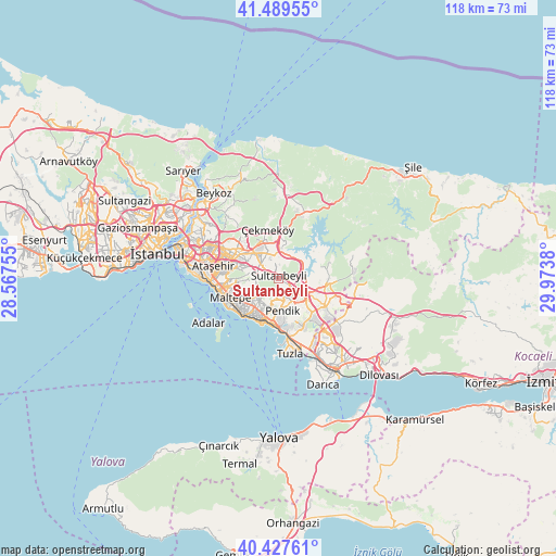
Sultanbeyli GPS coordinates[2]
40° 57' 38.592" North, 29° 16' 14.412" East
| Map corner | latitude | longitude |
|---|---|---|
| Upper-left | 41.48955°, | 28.56755° |
| Center: | 40.96072°, | 29.27067° |
| Lower-right: | 40.42761°, | 29.9738° |
| Map W x H: | 118.1×118.1 km | = 73.4×73.4mi |
| max Lat: | 42.02683° ⇑12% North |
| Sultanbeyli: | 40.96072° |
| min Lat: | ⇓88% South 35.9025° |
| min Long | Sultanbeyli | max Long |
| 25.90902° | 29.27067° | 44.60099° |
| W 18.7%⇐ | ⇒81.3% E |
Elevation
Elevation of Sultanbeyli is 151 m = 495 ft, and this is 566.4 m = 1858 ft below average elevation for this country.
| Max E: |
2682 m = 8799 ft | 76.9% |
| Avg. | 717.4 m = 2354 ft | |
| Sultanbeyli | 151 m = 495 ft | |
Min E: |
0 m = 0 ft | 23.1% |
See also: Sultanbeyli elevation on elevation.city.
Geographical zone
Sultanbeyli is located in North temperate zone (between Tropic of Cancer and the Arctic Circle). Distance of this Northern Tropic circle is 1948.5 km =1210.7 mi to South.| Distance of | km | miles | from Sultanbeyli |
|---|---|---|---|
| North Pole | 5452.7 | 3388.1 | to North |
| Arctic Circle | 2846.8 | 1768.9 | to North |
| Tropic Cancer | 1948.5 | 1210.7 | to South |
| Equator | 4554.4 | 2830 | to South |


Nearby cities:
15 places around Sultanbeyli: (largest is in red/bold)
• Adalan
17.9 km =11.1 mi,  238°
238°
• Adalar
15.5 km =9.6 mi,  228°
228°
• Ataşehir
13.2 km =8.2 mi,  280°
280°
• Balçık
16.5 km =10.3 mi,  126°
126°
• Kınalı
19.1 km =11.9 mi,  251°
251°
• Maltepe
10.1 km =6.3 mi, 253°
• Mollafeneri
20.5 km =12.7 mi,  113°
113°
• Pendik
9.3 km =5.8 mi,  179°
179°
• Samandıra
5.7 km =3.5 mi,  318°
318°
• Sancaktepe
5.7 km =3.5 mi, 324°
• Umraniye
13.7 km =8.5 mi,  296°
296°
• Çayırova
17.8 km =11.1 mi,  142°
142°
• Çekmeköy
11.8 km =7.3 mi, 319°
• Ümraniye
16.3 km =10.1 mi, 299°
• İçmeler
13.1 km =8.1 mi,  165°
165°
Sources, notices
• [Note1] Compared only with cities in Turkey existing in our database
• [Src1] Map data: © OpenStreetMap contributors (CC-BY-SA)
• [Src2] Other city data from geonames.org with taken over terms of usage.
• [Src3] Geographical zone / Annual Mean Temperature by Robert A. Rohde @ Wikipedia
