Sancaktepe geodata
Sancaktepe (Istanbul) is a populated place; located in Turkey in Europe/Istanbul (GMT+3) time zone. With population of 241,000 people, there are 43 cities with bigger population in this country. Compared to other cities in Turkey, 89% of cities are located further ↓South; 81.5% of cities are located further →East and 80.1% of cities have higher elevation than Sancaktepe. Note1


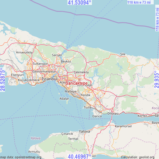
Sancaktepe GPS coordinates[2]
41° 0' 8.784" North, 29° 13' 54.732" East
| Map corner | latitude | longitude |
|---|---|---|
| Upper-left | 41.53094°, | 28.52875° |
| Center: | 41.00244°, | 29.23187° |
| Lower-right: | 40.46967°, | 29.935° |
| Map W x H: | 118×118 km | = 73.3×73.3mi |
| max Lat: | 42.02683° ⇑11% North |
| Sancaktepe: | 41.00244° |
| min Lat: | ⇓89% South 35.9025° |
| min Long | Sancaktepe | max Long |
| 25.90902° | 29.23187° | 44.60099° |
| W 18.5%⇐ | ⇒81.5% E |
Elevation
Elevation of Sancaktepe is 114 m = 374 ft, and this is 603.4 m = 1980 ft below average elevation for this country.
| Max E: |
2682 m = 8799 ft | 80.1% |
| Avg. | 717.4 m = 2354 ft | |
| Sancaktepe | 114 m = 374 ft | |
Min E: |
0 m = 0 ft | 19.9% |
See also: Sancaktepe elevation on elevation.city.
Geographical zone
Sancaktepe is located in North temperate zone (between Tropic of Cancer and the Arctic Circle). Distance of this Northern Tropic circle is 1953.1 km =1213.6 mi to South.| Distance of | km | miles | from Sancaktepe |
|---|---|---|---|
| North Pole | 5448 | 3385.2 | to North |
| Arctic Circle | 2842.1 | 1766 | to North |
| Tropic Cancer | 1953.1 | 1213.6 | to South |
| Equator | 4559 | 2832.8 | to South |


Nearby cities:
15 places around Sancaktepe: (largest is in red/bold)
• Adalan
18.5 km =11.5 mi,  220°
220°
• Adalar
17.1 km =10.6 mi,  209°
209°
• Ataşehir
9.9 km =6.2 mi,  257°
257°
• Kınalı
18.2 km =11.3 mi,  234°
234°
• Mahmut Şevket Paşa
17.1 km =10.6 mi,  348°
348°
• Maltepe
9.8 km =6.1 mi, 220°
• Pendik
14.3 km =8.9 mi,  166°
166°
• Samandıra
0.6 km =0.4 mi, 233°
• Sultanbeyli
5.7 km =3.5 mi,  144°
144°
• Umraniye
9.1 km =5.7 mi,  279°
279°
• Çekmeköy
6.2 km =3.9 mi,  313°
313°
• Ümraniye
11.5 km =7.1 mi,  287°
287°
• Üsküdar
18.4 km =11.4 mi, 277°
• İçmeler
18.5 km =11.5 mi,  159°
159°
• Şişli
21.5 km =13.4 mi, 287°
Sources, notices
• [Note1] Compared only with cities in Turkey existing in our database
• [Src1] Map data: © OpenStreetMap contributors (CC-BY-SA)
• [Src2] Other city data from geonames.org with taken over terms of usage.
• [Src3] Geographical zone / Annual Mean Temperature by Robert A. Rohde @ Wikipedia
