Ardahan geodata
Ardahan is a seat of a first-order administrative division; located in Turkey in Europe/Istanbul (GMT+3) time zone. With population of 21,020 people, there are 320 cities with bigger population in this country. Compared to other cities in Turkey, 92.6% of cities are located further ↓South; 95.1% of cities are located further ←West and 97.4% of cities have lower elevation than Ardahan. Note1


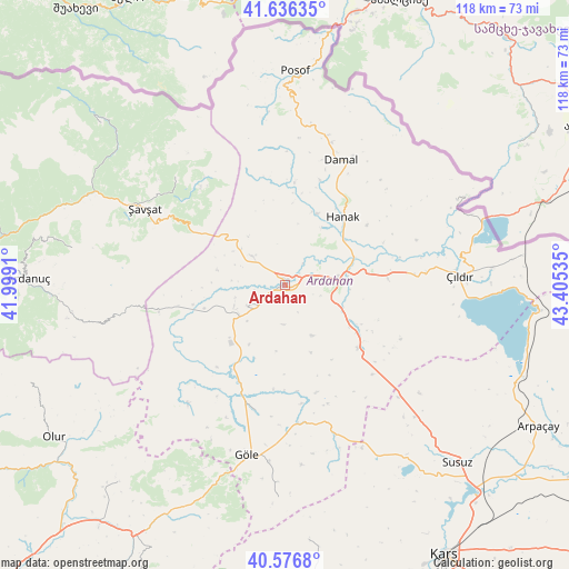
Ardahan GPS coordinates[2]
41° 6' 31.356" North, 42° 42' 7.992" East
| Map corner | latitude | longitude |
|---|---|---|
| Upper-left | 41.63635°, | 41.9991° |
| Center: | 41.10871°, | 42.70222° |
| Lower-right: | 40.5768°, | 43.40535° |
| Map W x H: | 117.8×117.8 km | = 73.2×73.2mi |
| max Lat: | 42.02683° ⇑7.4% North |
| Ardahan: | 41.10871° |
| min Lat: | ⇓92.6% South 35.9025° |
| min Long | Ardahan | max Long |
| 25.90902° | 42.70222° | 44.60099° |
| W 95.1%⇐ | ⇒4.9% E |
Elevation
Elevation of Ardahan is 1812 m = 5945 ft, and this is 1094.6 m = 3591 ft above average elevation for this country.
| Max E: |
2682 m = 8799 ft | 2.6% |
| Ardahan | 1812 m 5945 ft | |
| Avg. | 717.4 m = 2354 ft | |
Min E: |
0 m = 0 ft | 97.4% |
See also: Turkey elevation on elevation.city.
Geographical zone
Ardahan is located in North temperate zone (between Tropic of Cancer and the Arctic Circle). Distance of this Northern Tropic circle is 1964.9 km =1220.9 mi to South.| Distance of | km | miles | from Ardahan |
|---|---|---|---|
| North Pole | 5436.2 | 3377.9 | to North |
| Arctic Circle | 2830.3 | 1758.7 | to North |
| Tropic Cancer | 1964.9 | 1220.9 | to South |
| Equator | 4570.9 | 2840.2 | to South |


Nearby cities:
15 places around Ardahan: (largest is in red/bold)
• Aşağı Irmaklar
45 km =28 mi,  280°
280°
• Damal
28.2 km =17.5 mi,  23°
23°
• Doğruyol
52.2 km =32.4 mi,  95°
95°
• Eminbey
49.2 km =30.6 mi,  7°
7°
• Göle
36.6 km =22.7 mi,  192°
192°
• Hanak
18.1 km =11.2 mi,  39°
39°
• Hasköy
20.1 km =12.5 mi,  130°
130°
• Kurtkale
39.5 km =24.5 mi,  63°
63°
• Meydancık
51.3 km =31.9 mi,  310°
310°
• Posof
44.8 km =27.8 mi,  2°
2°
• Susuz
51.2 km =31.8 mi,  135°
135°
• Veliköy
32.2 km =20 mi,  315°
315°
• Yalnızçam
17.6 km =10.9 mi,  253°
253°
• Zurzuna
35.9 km =22.3 mi,  87°
87°
• Şavşat
32.1 km =19.9 mi,  297°
297°
Sources, notices
• [Note1] Compared only with cities in Turkey existing in our database
• [Src1] Map data: © OpenStreetMap contributors (CC-BY-SA)
• [Src2] Other city data from geonames.org with taken over terms of usage.
• [Src3] Geographical zone / Annual Mean Temperature by Robert A. Rohde @ Wikipedia
