Şavşat geodata
Şavşat (Artvin) is a seat of a second-order administrative division; located in Turkey in Europe/Istanbul (GMT+3) time zone. With population of 8,151 people, there are 571 cities with bigger population in this country. Compared to other cities in Turkey, 95% of cities are located further ↓South; 93.3% of cities are located further ←West and 84.9% of cities have lower elevation than Şavşat. Note1


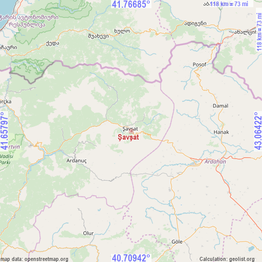
Şavşat GPS coordinates[2]
41° 14' 24.972" North, 42° 21' 39.924" East
| Map corner | latitude | longitude |
|---|---|---|
| Upper-left | 41.76685°, | 41.65797° |
| Center: | 41.24027°, | 42.36109° |
| Lower-right: | 40.70942°, | 43.06422° |
| Map W x H: | 117.6×117.6 km | = 73.1×73.1mi |
| max Lat: | 42.02683° ⇑5% North |
| Şavşat: | 41.24027° |
| min Lat: | ⇓95% South 35.9025° |
| min Long | Şavşat | max Long |
| 25.90902° | 42.36109° | 44.60099° |
| W 93.3%⇐ | ⇒6.7% E |
Elevation
Elevation of Şavşat is 1306 m = 4285 ft, and this is 588.6 m = 1931 ft above average elevation for this country.
| Max E: |
2682 m = 8799 ft | 15.1% |
| Şavşat | 1306 m 4285 ft | |
| Avg. | 717.4 m = 2354 ft | |
Min E: |
0 m = 0 ft | 84.9% |
See also: Turkey elevation on elevation.city.
Geographical zone
Şavşat is located in North temperate zone (between Tropic of Cancer and the Arctic Circle). Distance of this Northern Tropic circle is 1979.6 km =1230.1 mi to South.| Distance of | km | miles | from Şavşat |
|---|---|---|---|
| North Pole | 5421.6 | 3368.8 | to North |
| Arctic Circle | 2815.7 | 1749.6 | to North |
| Tropic Cancer | 1979.6 | 1230.1 | to South |
| Equator | 4585.5 | 2849.3 | to South |


Nearby cities:
15 places around Şavşat: (largest is in red/bold)
• Ardahan
32.1 km =19.9 mi,  117°
117°
• Ardanuç
27.9 km =17.3 mi,  243°
243°
• Artvin
45.6 km =28.3 mi,  261°
261°
• Aşağı Irmaklar
16.9 km =10.5 mi,  247°
247°
• Camili
46.8 km =29.1 mi,  304°
304°
• Damal
41.3 km =25.7 mi,  74°
74°
• Eminbey
49 km =30.4 mi,  45°
45°
• Hanak
40.1 km =24.9 mi,  91°
91°
• Meydancık
21.5 km =13.4 mi,  331°
331°
• Ortaköy
31.6 km =19.6 mi,  272°
272°
• Posof
43 km =26.7 mi, 45°
• Seyitler
44.1 km =27.4 mi, 263°
• Veliköy
10.3 km =6.4 mi,  35°
35°
• Yalnızçam
22.8 km =14.2 mi,  149°
149°
• Zeytinlik
44.5 km =27.7 mi, 251°
Sources, notices
• [Note1] Compared only with cities in Turkey existing in our database
• [Src1] Map data: © OpenStreetMap contributors (CC-BY-SA)
• [Src2] Other city data from geonames.org with taken over terms of usage.
• [Src3] Geographical zone / Annual Mean Temperature by Robert A. Rohde @ Wikipedia
