Akçakoca geodata
Akçakoca (Düzce) is a seat of a second-order administrative division; located in Turkey in Europe/Istanbul (GMT+3) time zone. With population of 35,151 people, there are 226 cities with bigger population in this country. Compared to other cities in Turkey, 92.1% of cities are located further ↓South; 70.1% of cities are located further →East and 87.1% of cities have higher elevation than Akçakoca. Note1


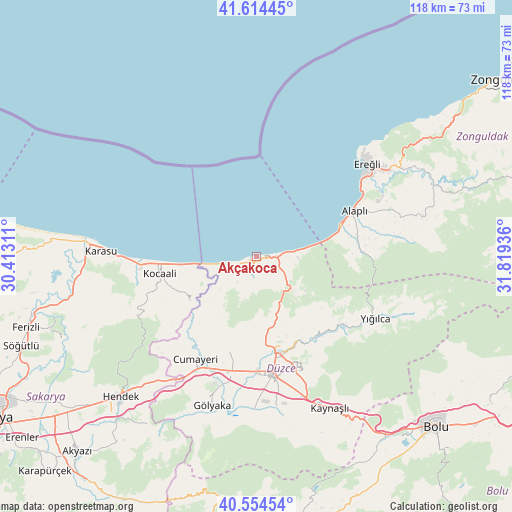
Akçakoca GPS coordinates[2]
41° 5' 11.868" North, 31° 6' 58.428" East
| Map corner | latitude | longitude |
|---|---|---|
| Upper-left | 41.61445°, | 30.41311° |
| Center: | 41.08663°, | 31.11623° |
| Lower-right: | 40.55454°, | 31.81936° |
| Map W x H: | 117.9×117.9 km | = 73.3×73.3mi |
| max Lat: | 42.02683° ⇑7.9% North |
| Akçakoca: | 41.08663° |
| min Lat: | ⇓92.1% South 35.9025° |
| min Long | Akçakoca | max Long |
| 25.90902° | 31.11623° | 44.60099° |
| W 29.9%⇐ | ⇒70.1% E |
Elevation
Elevation of Akçakoca is 59 m = 194 ft, and this is 658.4 m = 2160 ft below average elevation for this country.
| Max E: |
2682 m = 8799 ft | 87.1% |
| Avg. | 717.4 m = 2354 ft | |
| Akçakoca | 59 m = 194 ft | |
Min E: |
0 m = 0 ft | 12.9% |
See also: Turkey elevation on elevation.city.
Geographical zone
Akçakoca is located in North temperate zone (between Tropic of Cancer and the Arctic Circle). Distance of this Northern Tropic circle is 1962.5 km =1219.4 mi to South.| Distance of | km | miles | from Akçakoca |
|---|---|---|---|
| North Pole | 5438.7 | 3379.5 | to North |
| Arctic Circle | 2832.8 | 1760.2 | to North |
| Tropic Cancer | 1962.5 | 1219.4 | to South |
| Equator | 4568.4 | 2838.7 | to South |


Nearby cities:
15 places around Akçakoca: (largest is in red/bold)
• Alaplı
24.9 km =15.5 mi,  64°
64°
• Cumayeri
27.4 km =17 mi,  210°
210°
• Düzce
27.8 km =17.3 mi,  171°
171°
• Ereğli
33.4 km =20.8 mi,  49°
49°
• Gölyaka
35.9 km =22.3 mi,  196°
196°
• Gümüşova
30.4 km =18.9 mi, 208°
• Karasu
35.2 km =21.9 mi,  273°
273°
• Karasu Mahallesi
27.8 km =17.3 mi, 266°
• Kaynaşlı
39.3 km =24.4 mi,  153°
153°
• Kocaali
22.4 km =13.9 mi,  260°
260°
• Konuralp
20.3 km =12.6 mi, 173°
• Ormanlı
42.6 km =26.5 mi,  78°
78°
• Ortaköy
39 km =24.2 mi,  251°
251°
• Yığılca
30.9 km =19.2 mi,  117°
117°
• Çilimli
22.2 km =13.8 mi,  194°
194°
Sources, notices
• [Note1] Compared only with cities in Turkey existing in our database
• [Src1] Map data: © OpenStreetMap contributors (CC-BY-SA)
• [Src2] Other city data from geonames.org with taken over terms of usage.
• [Src3] Geographical zone / Annual Mean Temperature by Robert A. Rohde @ Wikipedia
