Pınarbaşı geodata
Pınarbaşı (Kastamonu) is a seat of a second-order administrative division; located in Turkey in Europe/Istanbul (GMT+3) time zone. With population of 2,491 people, there are 901 cities with bigger population in this country. Compared to other cities in Turkey, 98% of cities are located further ↓South; 61.8% of cities are located further →East and 51.1% of cities have higher elevation than Pınarbaşı. Note1


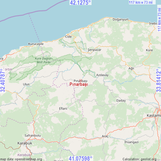
Pınarbaşı GPS coordinates[2]
41° 36' 13.968" North, 33° 6' 39.564" East
| Map corner | latitude | longitude |
|---|---|---|
| Upper-left | 42.1275°, | 32.40787° |
| Center: | 41.60388°, | 33.11099° |
| Lower-right: | 41.07598°, | 33.81412° |
| Map W x H: | 116.9×116.9 km | = 72.6×72.6mi |
| max Lat: | 42.02683° ⇑2% North |
| Pınarbaşı: | 41.60388° |
| min Lat: | ⇓98% South 35.9025° |
| min Long | Pınarbaşı | max Long |
| 25.90902° | 33.11099° | 44.60099° |
| W 38.2%⇐ | ⇒61.8% E |
Elevation
Elevation of Pınarbaşı is 672 m = 2205 ft, and this is 45.4 m = 149 ft below average elevation for this country.
| Max E: |
2682 m = 8799 ft | 51.1% |
| Avg. | 717.4 m = 2354 ft | |
| Pınarbaşı | 672 m = 2205 ft | |
Min E: |
0 m = 0 ft | 48.9% |
See also: Turkey elevation on elevation.city.
Geographical zone
Pınarbaşı is located in North temperate zone (between Tropic of Cancer and the Arctic Circle). Distance of this Northern Tropic circle is 2020 km =1255.2 mi to South.| Distance of | km | miles | from Pınarbaşı |
|---|---|---|---|
| North Pole | 5381.1 | 3343.7 | to North |
| Arctic Circle | 2775.3 | 1724.5 | to North |
| Tropic Cancer | 2020 | 1255.2 | to South |
| Equator | 4625.9 | 2874.4 | to South |


Nearby cities:
15 places around Pınarbaşı: (largest is in red/bold)
• Akkaya
52.9 km =32.9 mi,  143°
143°
• Araç
44.1 km =27.4 mi,  155°
155°
• Arıt
41.5 km =25.8 mi,  282°
282°
• Azdavay
16.3 km =10.1 mi,  74°
74°
• Ağlı
37.9 km =23.5 mi,  76°
76°
• Cide
33.2 km =20.6 mi,  344°
344°
• Daday
32.7 km =20.3 mi,  115°
115°
• Eflani
23.8 km =14.8 mi,  212°
212°
• Kurucaşile
41.8 km =26 mi,  308°
308°
• Ovacuma
34.4 km =21.4 mi,  239°
239°
• Safranbolu
52.4 km =32.6 mi,  221°
221°
• Seydiler
50.5 km =31.4 mi,  87°
87°
• Ulus
39.1 km =24.3 mi,  266°
266°
• İğdir
42.1 km =26.2 mi,  177°
177°
• Şenpazar
24.9 km =15.5 mi,  23°
23°
Sources, notices
• [Note1] Compared only with cities in Turkey existing in our database
• [Src1] Map data: © OpenStreetMap contributors (CC-BY-SA)
• [Src2] Other city data from geonames.org with taken over terms of usage.
• [Src3] Geographical zone / Annual Mean Temperature by Robert A. Rohde @ Wikipedia
