Kastamonu geodata
Kastamonu is a seat of a first-order administrative division; located in Turkey in Europe/Istanbul (GMT+3) time zone. With population of 70,402 people, there are 132 cities with bigger population in this country. Compared to other cities in Turkey, 96.2% of cities are located further ↓South; 59.2% of cities are located further →East and 54.7% of cities have lower elevation than Kastamonu. Note1


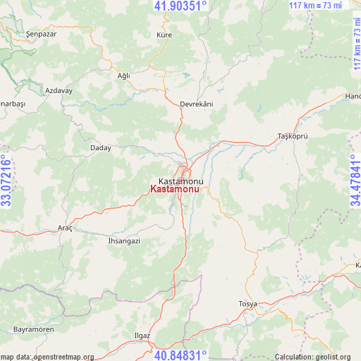
Kastamonu GPS coordinates[2]
41° 22' 40.98" North, 33° 46' 31.008" East
| Map corner | latitude | longitude |
|---|---|---|
| Upper-left | 41.90351°, | 33.07216° |
| Center: | 41.37805°, | 33.77528° |
| Lower-right: | 40.84831°, | 34.47841° |
| Map W x H: | 117.3×117.3 km | = 72.9×72.9mi |
| max Lat: | 42.02683° ⇑3.8% North |
| Kastamonu: | 41.37805° |
| min Lat: | ⇓96.2% South 35.9025° |
| min Long | Kastamonu | max Long |
| 25.90902° | 33.77528° | 44.60099° |
| W 40.8%⇐ | ⇒59.2% E |
Elevation
Elevation of Kastamonu is 786 m = 2579 ft, and this is 68.6 m = 225 ft above average elevation for this country.
| Max E: |
2682 m = 8799 ft | 45.3% |
| Kastamonu | 786 m 2579 ft | |
| Avg. | 717.4 m = 2354 ft | |
Min E: |
0 m = 0 ft | 54.7% |
See also: Kastamonu elevation on elevation.city.
Geographical zone
Kastamonu is located in North temperate zone (between Tropic of Cancer and the Arctic Circle). Distance of this Northern Tropic circle is 1994.9 km =1239.6 mi to South.| Distance of | km | miles | from Kastamonu |
|---|---|---|---|
| North Pole | 5406.3 | 3359.3 | to North |
| Arctic Circle | 2800.4 | 1740.1 | to North |
| Tropic Cancer | 1994.9 | 1239.6 | to South |
| Equator | 4600.8 | 2858.8 | to South |


Nearby cities:
15 places around Kastamonu: (largest is in red/bold)
• Akkaya
30 km =18.6 mi,  233°
233°
• Araç
40.3 km =25 mi,  248°
248°
• Azdavay
49.3 km =30.6 mi,  306°
306°
• Ağlı
38.9 km =24.2 mi,  331°
331°
• Boyalı
55.5 km =34.5 mi, 225°
• Daday
28.1 km =17.5 mi,  293°
293°
• Devrekani
25.6 km =15.9 mi,  12°
12°
• Ilgaz
51.9 km =32.2 mi,  193°
193°
• Kuzyaka
16.8 km =10.4 mi,  195°
195°
• Küre
47.9 km =29.8 mi,  353°
353°
• Seydiler
27.3 km =17 mi, 349°
• Taşköprü
39.4 km =24.5 mi,  68°
68°
• Tosya
46 km =28.6 mi,  151°
151°
• İhsangazi
26.7 km =16.6 mi,  223°
223°
• İğdir
55.9 km =34.7 mi, 252°
Sources, notices
• [Note1] Compared only with cities in Turkey existing in our database
• [Src1] Map data: © OpenStreetMap contributors (CC-BY-SA)
• [Src2] Other city data from geonames.org with taken over terms of usage.
• [Src3] Geographical zone / Annual Mean Temperature by Robert A. Rohde @ Wikipedia
