Magong geodata
Magong (Taiwan) is a seat of a second-order administrative division; located in Taiwan in Asia/Taipei (GMT+8) time zone. With population of 56,435 people, there are 16 cities with bigger population in this country. Compared to other cities in Taiwan, 64.9% of cities are located further ↑North; 97.3% of cities are located further →East and 83.8% of cities have higher elevation than Magong. Note1


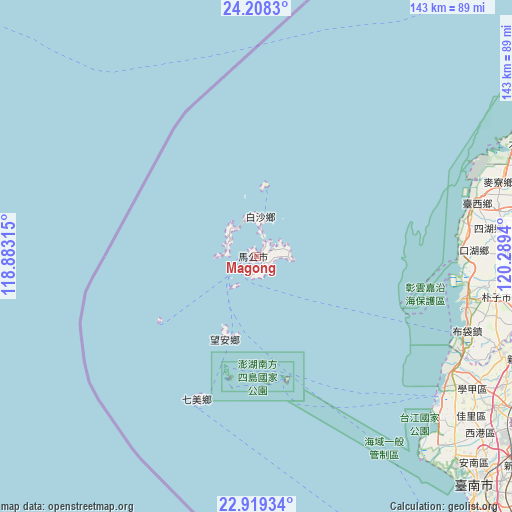
Magong GPS coordinates[2]
23° 33' 55.44" North, 119° 35' 10.572" East
| Map corner | latitude | longitude |
|---|---|---|
| Upper-left | 24.2083°, | 118.88315° |
| Center: | 23.5654°, | 119.58627° |
| Lower-right: | 22.91934°, | 120.2894° |
| Map W x H: | 143.3×143.3 km | = 89×89mi |
| max Lat: | 26.15039° ⇑64.9% North |
| Magong: | 23.5654° |
| min Lat: | ⇓35.1% South 22.00417° |
| min Long | Magong | max Long |
| 118.31712° | 119.58627° | 121.84424° |
| W 2.7%⇐ | ⇒97.3% E |
Elevation
Elevation of Magong is 14 m = 46 ft, and this is 64.5 m = 212 ft below average elevation for this country.
| Max E: |
505 m = 1657 ft | 83.8% |
| Avg. | 78.5 m = 258 ft | |
| Magong | 14 m = 46 ft | |
Min E: |
8 m = 26 ft | 16.2% |
See also: Magong elevation on elevation.city.
Geographical zone
Magong is located in North temperate zone (between Tropic of Cancer and the Arctic Circle). Distance of this Northern Tropic circle is 14.3 km =8.9 mi to South.| Distance of | km | miles | from Magong |
|---|---|---|---|
| North Pole | 7386.8 | 4589.9 | to North |
| Arctic Circle | 4780.9 | 2970.7 | to North |
| Tropic Cancer | 14.3 | 8.9 | to South |
| Equator | 2620.2 | 1628.1 | to South |


Nearby cities:
15 places around Magong: (largest is in red/bold)
• Chang-hua
114.3 km =71 mi,  60°
60°
• Douliu
98.8 km =61.4 mi,  80°
80°
• Fengshan
131.1 km =81.5 mi,  142°
142°
• Jiayi Shi
88.5 km =55 mi,  96°
96°
• Kaohsiung
129.1 km =80.2 mi, 144°
• Lugu
120.5 km =74.9 mi, 80°
• Nantou
116.4 km =72.3 mi,  70°
70°
• Pizitou
88 km =54.7 mi, 95°
• Taibao
77 km =47.8 mi, 98°
• Taichung
129 km =80.2 mi, 59°
• Tainan
90.5 km =56.2 mi,  134°
134°
• Xinying
79.3 km =49.3 mi,  111°
111°
• Yuanlin
109.7 km =68.2 mi, 66°
• Yujing
101.9 km =63.3 mi,  118°
118°
• Zhongxing New Village
120.1 km =74.6 mi, 68°
Sources, notices
• [Note1] Compared only with cities in Taiwan existing in our database
• [Src1] Map data: © OpenStreetMap contributors (CC-BY-SA)
• [Src2] Other city data from geonames.org with taken over terms of usage.
• [Src3] Geographical zone / Annual Mean Temperature by Robert A. Rohde @ Wikipedia
