Kaohsiung geodata
Kaohsiung (Takao) is a seat of a first-order administrative division; located in Taiwan in Asia/Taipei (GMT+8) time zone. With population of 1,519,711 people, there is 1 city with bigger population in this country. Compared to other cities in Taiwan, 94.6% of cities are located further ↑North; 86.5% of cities are located further →East and 97.3% of cities have higher elevation than Kaohsiung. Note1


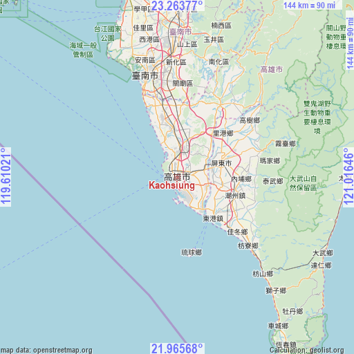
Kaohsiung GPS coordinates[2]
22° 36' 58.536" North, 120° 18' 47.988" East
| Map corner | latitude | longitude |
|---|---|---|
| Upper-left | 23.26377°, | 119.61021° |
| Center: | 22.61626°, | 120.31333° |
| Lower-right: | 21.96568°, | 121.01646° |
| Map W x H: | 144.3×144.3 km | = 89.7×89.7mi |
| max Lat: | 26.15039° ⇑94.6% North |
| Kaohsiung: | 22.61626° |
| min Lat: | ⇓5.4% South 22.00417° |
| min Long | Kaohsiung | max Long |
| 118.31712° | 120.31333° | 121.84424° |
| W 13.5%⇐ | ⇒86.5% E |
Elevation
Elevation of Kaohsiung is 9 m = 30 ft, and this is 69.5 m = 228 ft below average elevation for this country.
| Max E: |
505 m = 1657 ft | 97.3% |
| Avg. | 78.5 m = 258 ft | |
| Kaohsiung | 9 m = 30 ft | |
Min E: |
8 m = 26 ft | 2.7% |
See also: Kaohsiung elevation on elevation.city.
Geographical zone
Kaohsiung is located in North Torrid zone (between Equator and Tropic of Cancer). Distance of this Northern Tropic circle is 91.2 km =56.7 mi to North.| Distance of | km | miles | from Kaohsiung |
|---|---|---|---|
| North Pole | 7492.4 | 4655.6 | to North |
| Arctic Circle | 4886.5 | 3036.3 | to North |
| Tropic Cancer | 91.2 | 56.7 | to North |
| Equator | 2514.7 | 1562.6 | to South |


Nearby cities:
15 places around Kaohsiung: (largest is in red/bold)
• Donggang
21.8 km =13.5 mi,  140°
140°
• Douliu
123.8 km =76.9 mi,  10°
10°
• Fengshan
5.1 km =3.2 mi,  76°
76°
• Hengchun
81.2 km =50.5 mi,  146°
146°
• Jiayi Shi
96.9 km =60.2 mi, 8°
• Lugu
133.4 km =82.9 mi,  19°
19°
• Magong
129.1 km =80.2 mi,  324°
324°
• Pingtung
19 km =11.8 mi,  71°
71°
• Pizitou
97.6 km =60.6 mi, 7°
• Taibao
93.8 km =58.3 mi,  1°
1°
• Tainan
42.9 km =26.7 mi,  346°
346°
• Taitung
86.8 km =53.9 mi, 79°
• Taitung City
86.7 km =53.9 mi, 79°
• Xinying
76.8 km =47.7 mi,  359°
359°
• Yujing
58.6 km =36.4 mi, 15°
Sources, notices
• [Note1] Compared only with cities in Taiwan existing in our database
• [Src1] Map data: © OpenStreetMap contributors (CC-BY-SA)
• [Src2] Other city data from geonames.org with taken over terms of usage.
• [Src3] Geographical zone / Annual Mean Temperature by Robert A. Rohde @ Wikipedia
