Fengshan geodata
Fengshan (Takao) is a seat of a second-order administrative division; located in Taiwan in Asia/Taipei (GMT+8) time zone. In our database, there are 25 cities with bigger population. Compared to other cities in Taiwan, 91.9% of cities are located further ↑North; 81.1% of cities are located further →East and 75.7% of cities have higher elevation than Fengshan. Note1


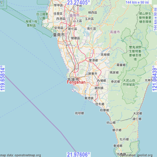
Fengshan GPS coordinates[2]
22° 37' 35.724" North, 120° 21' 40.536" East
| Map corner | latitude | longitude |
|---|---|---|
| Upper-left | 23.27405°, | 119.65814° |
| Center: | 22.62659°, | 120.36126° |
| Lower-right: | 21.97606°, | 121.06439° |
| Map W x H: | 144.3×144.3 km | = 89.7×89.7mi |
| max Lat: | 26.15039° ⇑91.9% North |
| Fengshan: | 22.62659° |
| min Lat: | ⇓8.1% South 22.00417° |
| min Long | Fengshan | max Long |
| 118.31712° | 120.36126° | 121.84424° |
| W 18.9%⇐ | ⇒81.1% E |
Elevation
Elevation of Fengshan is 19 m = 62 ft, and this is 59.5 m = 195 ft below average elevation for this country.
| Max E: |
505 m = 1657 ft | 75.7% |
| Avg. | 78.5 m = 258 ft | |
| Fengshan | 19 m = 62 ft | |
Min E: |
8 m = 26 ft | 24.3% |
See also: Taiwan elevation on elevation.city.
Geographical zone
Fengshan is located in North Torrid zone (between Equator and Tropic of Cancer). Distance of this Northern Tropic circle is 90.1 km =56 mi to North.| Distance of | km | miles | from Fengshan |
|---|---|---|---|
| North Pole | 7491.2 | 4654.8 | to North |
| Arctic Circle | 4885.3 | 3035.6 | to North |
| Tropic Cancer | 90.1 | 56 | to North |
| Equator | 2515.8 | 1563.2 | to South |


Nearby cities:
15 places around Fengshan: (largest is in red/bold)
• Donggang
20.1 km =12.5 mi,  153°
153°
• Douliu
121.8 km =75.7 mi,  8°
8°
• Hengchun
79.6 km =49.5 mi, 150°
• Jiayi Shi
95.2 km =59.2 mi, 5°
• Kaohsiung
5.1 km =3.2 mi,  256°
256°
• Lugu
130.8 km =81.3 mi,  17°
17°
• Magong
131.1 km =81.5 mi,  322°
322°
• Pingtung
13.9 km =8.6 mi,  69°
69°
• Pizitou
95.9 km =59.6 mi, 5°
• Taibao
92.7 km =57.6 mi,  358°
358°
• Tainan
43.2 km =26.8 mi,  339°
339°
• Taitung
81.7 km =50.8 mi,  79°
79°
• Taitung City
81.7 km =50.8 mi, 79°
• Xinying
75.8 km =47.1 mi, 356°
• Yujing
56.4 km =35 mi, 10°
Sources, notices
• [Note1] Compared only with cities in Taiwan existing in our database
• [Src1] Map data: © OpenStreetMap contributors (CC-BY-SA)
• [Src2] Other city data from geonames.org with taken over terms of usage.
• [Src3] Geographical zone / Annual Mean Temperature by Robert A. Rohde @ Wikipedia
