Matonga geodata
Matonga (Simiyu) is a populated place; located in Tanzania in Africa/Dar_es_Salaam (GMT+3) time zone. With population of 11,828 people, there are 217 cities with bigger population in this country. Compared to other cities in Tanzania, 91.6% of cities are located further ↓South; 63.3% of cities are located further →East and 69.2% of cities have lower elevation than Matonga. Note1


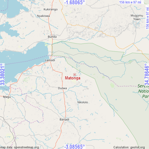
Matonga GPS coordinates[2]
2° 22' 59.988" South, 34° 4' 59.988" East
| Map corner | latitude | longitude |
|---|---|---|
| Upper-left | -1.68065°, | 33.38021° |
| Center: | -2.38333°, | 34.08333° |
| Lower-right: | -3.08565°, | 34.78646° |
| Map W x H: | 156.2×156.2 km | = 97.1×97.1mi |
| max Lat: | -1.14389° ⇑8.4% North |
| Matonga: | -2.38333° |
| min Lat: | ⇓91.6% South -11.36667° |
| min Long | Matonga | max Long |
| 29.62667° | 34.08333° | 40.33333° |
| W 36.7%⇐ | ⇒63.3% E |
Elevation
Elevation of Matonga is 1281 m = 4203 ft, and this is 338.2 m = 1110 ft above average elevation for this country.
| Max E: |
2377 m = 7799 ft | 30.8% |
| Matonga | 1281 m 4203 ft | |
| Avg. | 942.8 m = 3093 ft | |
Min E: |
0 m = 0 ft | 69.2% |
See also: Tanzania elevation on elevation.city.
Geographical zone
Matonga is located in South Torrid zone (between Equator and Tropic of Capricorn). Distance of Equator is 265 km =164.7 mi to North.| Distance of | km | miles | from Matonga |
|---|---|---|---|
| Equator | 265 | 164.7 | to North |
| Tropic Capricorn | 2340.9 | 1454.6 | to South |
| Antarctic Circle | 7136.2 | 4434.2 | to South |
| South Pole | 9742.1 | 6053.5 | to South |


Nearby cities:
15 places around Matonga: (largest is in red/bold)
• Bariadi
47.6 km =29.6 mi,  193°
193°
• Bunda
44.2 km =27.5 mi,  326°
326°
• Butiama
69.8 km =43.4 mi,  349°
349°
• Issenye
50.9 km =31.6 mi,  33°
33°
• Kibara
75 km =46.6 mi,  290°
290°
• Kihangara
84.4 km =52.4 mi,  254°
254°
• Kisesa
78.2 km =48.6 mi,  174°
174°
• Malya
91.7 km =57 mi,  223°
223°
• Maswa
35.2 km =21.9 mi,  198°
198°
• Mugango
88.7 km =55.1 mi, 331°
• Mugumu
90.6 km =56.3 mi,  49°
49°
• Nyakabindi
29.9 km =18.6 mi, 201°
• Nyalikungu
95 km =59 mi, 200°
• Nyamuswa
54.2 km =33.7 mi, 352°
• Nyanguge
99.9 km =62.1 mi,  259°
259°
Sources, notices
• [Note1] Compared only with cities in Tanzania existing in our database
• [Src1] Map data: © OpenStreetMap contributors (CC-BY-SA)
• [Src2] Other city data from geonames.org with taken over terms of usage.
• [Src3] Geographical zone / Annual Mean Temperature by Robert A. Rohde @ Wikipedia
