Somanda geodata
Somanda (Simiyu) is a populated place; located in Tanzania in Africa/Dar_es_Salaam (GMT+3) time zone. With population of 33,932 people, there are 52 cities with bigger population in this country. Compared to other cities in Tanzania, 77.6% of cities are located further ↓South; 66.8% of cities are located further →East and 64% of cities have lower elevation than Somanda. Note1


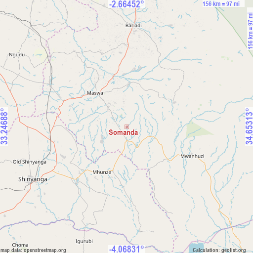
Somanda GPS coordinates[2]
3° 22' 0.012" South, 33° 57' 0" East
| Map corner | latitude | longitude |
|---|---|---|
| Upper-left | -2.66452°, | 33.24688° |
| Center: | -3.36667°, | 33.95° |
| Lower-right: | -4.06831°, | 34.65313° |
| Map W x H: | 156.1×156.1 km | = 97×97mi |
| max Lat: | -1.14389° ⇑22.4% North |
| Somanda: | -3.36667° |
| min Lat: | ⇓77.6% South -11.36667° |
| min Long | Somanda | max Long |
| 29.62667° | 33.95° | 40.33333° |
| W 33.2%⇐ | ⇒66.8% E |
Elevation
Elevation of Somanda is 1208 m = 3963 ft, and this is 265.2 m = 870 ft above average elevation for this country.
| Max E: |
2377 m = 7799 ft | 36% |
| Somanda | 1208 m 3963 ft | |
| Avg. | 942.8 m = 3093 ft | |
Min E: |
0 m = 0 ft | 64% |
See also: Tanzania elevation on elevation.city.
Geographical zone
Somanda is located in South Torrid zone (between Equator and Tropic of Capricorn). Distance of Equator is 374.3 km =232.6 mi to North.| Distance of | km | miles | from Somanda |
|---|---|---|---|
| Equator | 374.3 | 232.6 | to North |
| Tropic Capricorn | 2231.6 | 1386.7 | to South |
| Antarctic Circle | 7026.8 | 4366.2 | to South |
| South Pole | 9632.7 | 5985.5 | to South |


Nearby cities:
15 places around Somanda: (largest is in red/bold)
• Bariadi
63.1 km =39.2 mi,  3°
3°
• Igurubi
75.7 km =47 mi,  201°
201°
• Kisesa
38.5 km =23.9 mi,  35°
35°
• Kishapu
29.3 km =18.2 mi, 198°
• Lalago
9.3 km =5.8 mi,  180°
180°
• Malampaka
53 km =32.9 mi,  299°
299°
• Malya
64.3 km =40 mi,  311°
311°
• Maswa
76.1 km =47.3 mi, 2°
• Mwadui
43.9 km =27.3 mi,  242°
242°
• Ngudu
81.6 km =50.7 mi, 303°
• Nyakabindi
81.6 km =50.7 mi, 2°
• Nyalikungu
27.5 km =17.1 mi,  317°
317°
• Old Shinyanga
64.4 km =40 mi,  251°
251°
• Shinyanga
67.4 km =41.9 mi, 240°
• Songwa
50.9 km =31.6 mi, 250°
Sources, notices
• [Note1] Compared only with cities in Tanzania existing in our database
• [Src1] Map data: © OpenStreetMap contributors (CC-BY-SA)
• [Src2] Other city data from geonames.org with taken over terms of usage.
• [Src3] Geographical zone / Annual Mean Temperature by Robert A. Rohde @ Wikipedia
