Muheza geodata
Muheza (Tanga) is a populated place; located in Tanzania in Africa/Dar_es_Salaam (GMT+3) time zone. With population of 17,000 people, there are 163 cities with bigger population in this country. Compared to other cities in Tanzania, 50.3% of cities are located further ↓South; 80.1% of cities are located further ←West and 85% of cities have higher elevation than Muheza. Note1


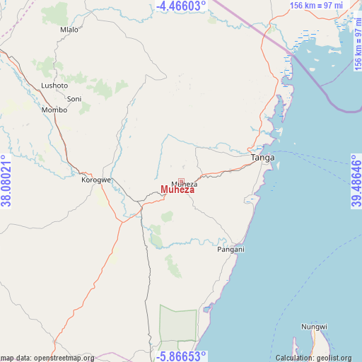
Muheza GPS coordinates[2]
5° 10' 0.012" South, 38° 46' 59.988" East
| Map corner | latitude | longitude |
|---|---|---|
| Upper-left | -4.46603°, | 38.08021° |
| Center: | -5.16667°, | 38.78333° |
| Lower-right: | -5.86653°, | 39.48646° |
| Map W x H: | 155.7×155.7 km | = 96.7×96.7mi |
| max Lat: | -1.14389° ⇑49.7% North |
| Muheza: | -5.16667° |
| min Lat: | ⇓50.3% South -11.36667° |
| min Long | Muheza | max Long |
| 29.62667° | 38.78333° | 40.33333° |
| W 80.1%⇐ | ⇒19.9% E |
Elevation
Elevation of Muheza is 183 m = 600 ft, and this is 759.8 m = 2493 ft below average elevation for this country.
| Max E: |
2377 m = 7799 ft | 85% |
| Avg. | 942.8 m = 3093 ft | |
| Muheza | 183 m = 600 ft | |
Min E: |
0 m = 0 ft | 15% |
See also: Tanzania elevation on elevation.city.
Geographical zone
Muheza is located in South Torrid zone (between Equator and Tropic of Capricorn). Distance of Equator is 574.5 km =357 mi to North.| Distance of | km | miles | from Muheza |
|---|---|---|---|
| Equator | 574.5 | 357 | to North |
| Tropic Capricorn | 2031.4 | 1262.3 | to South |
| Antarctic Circle | 6826.7 | 4241.9 | to South |
| South Pole | 9432.6 | 5861.1 | to South |


Nearby cities:
15 places around Muheza: (largest is in red/bold)
• Chanika
89.3 km =55.5 mi,  251°
251°
• Lushoto
69.9 km =43.4 mi,  307°
307°
• Magomeni
74.2 km =46.1 mi,  264°
264°
• Majengo
22.2 km =13.8 mi,  85°
85°
• Makuyuni
89.7 km =55.7 mi,  302°
302°
• Maramba
22.6 km =14 mi, 305°
• Matui
71.8 km =44.6 mi, 304°
• Mazinde
74.8 km =46.5 mi, 303°
• Mkokotoni
94.5 km =58.7 mi,  146°
146°
• Mlalo
30.8 km =19.1 mi,  32°
32°
• Mwanga
76.4 km =47.5 mi, 302°
• Nungwi
84.4 km =52.4 mi,  137°
137°
• Pangani
35.7 km =22.2 mi, 143°
• Soni
58 km =36 mi, 307°
• Tanga
36.6 km =22.7 mi,  72°
72°
Sources, notices
• [Note1] Compared only with cities in Tanzania existing in our database
• [Src1] Map data: © OpenStreetMap contributors (CC-BY-SA)
• [Src2] Other city data from geonames.org with taken over terms of usage.
• [Src3] Geographical zone / Annual Mean Temperature by Robert A. Rohde @ Wikipedia
