Mingoyo geodata
Mingoyo (Lindi) is a populated place; located in Tanzania in Africa/Dar_es_Salaam (GMT+3) time zone. With population of 10,480 people, there are 234 cities with bigger population in this country. Compared to other cities in Tanzania, 89.2% of cities are located further ↑North; 95.5% of cities are located further ←West and 90.6% of cities have higher elevation than Mingoyo. Note1


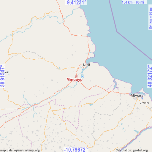
Mingoyo GPS coordinates[2]
10° 6' 18.936" South, 39° 37' 6.924" East
| Map corner | latitude | longitude |
|---|---|---|
| Upper-left | -9.41231°, | 38.91547° |
| Center: | -10.10526°, | 39.61859° |
| Lower-right: | -10.79672°, | 40.32172° |
| Map W x H: | 153.9×153.9 km | = 95.6×95.6mi |
| max Lat: | -1.14389° ⇑89.2% North |
| Mingoyo: | -10.10526° |
| min Lat: | ⇓10.8% South -11.36667° |
| min Long | Mingoyo | max Long |
| 29.62667° | 39.61859° | 40.33333° |
| W 95.5%⇐ | ⇒4.5% E |
Elevation
Elevation of Mingoyo is 43 m = 141 ft, and this is 899.8 m = 2952 ft below average elevation for this country.
| Max E: |
2377 m = 7799 ft | 90.6% |
| Avg. | 942.8 m = 3093 ft | |
| Mingoyo | 43 m = 141 ft | |
Min E: |
0 m = 0 ft | 9.4% |
See also: Tanzania elevation on elevation.city.
Geographical zone
Mingoyo is located in South Torrid zone (between Equator and Tropic of Capricorn). Distance of Equator is 1123.6 km =698.2 mi to North.| Distance of | km | miles | from Mingoyo |
|---|---|---|---|
| Equator | 1123.6 | 698.2 | to North |
| Tropic Capricorn | 1482.3 | 921.1 | to South |
| Antarctic Circle | 6277.6 | 3900.7 | to South |
| South Pole | 8883.5 | 5519.9 | to South |


Nearby cities:
15 places around Mingoyo: (largest is in red/bold)
• Kitama
69.1 km =42.9 mi,  169°
169°
• Kitangari
68.1 km =42.3 mi,  207°
207°
• Lindi
16.1 km =10 mi,  41°
41°
• Madimba
84.8 km =52.7 mi,  112°
112°
• Mahuta
86.6 km =53.8 mi,  192°
192°
• Mbekenyera
70.5 km =43.8 mi,  279°
279°
• Mtama
35.1 km =21.8 mi,  231°
231°
• Mtwara
64.4 km =40 mi, 106°
• Namikupa
81 km =50.3 mi,  181°
181°
• Nanganga
59.9 km =37.2 mi,  238°
238°
• Nanhyanga
77.6 km =48.2 mi, 185°
• Nanyamba
68.4 km =42.5 mi,  159°
159°
• Nyangao
44.6 km =27.7 mi, 235°
• Ruangwa
75.1 km =46.7 mi,  273°
273°
• Tandahimba
71.7 km =44.6 mi, 178°
Sources, notices
• [Note1] Compared only with cities in Tanzania existing in our database
• [Src1] Map data: © OpenStreetMap contributors (CC-BY-SA)
• [Src2] Other city data from geonames.org with taken over terms of usage.
• [Src3] Geographical zone / Annual Mean Temperature by Robert A. Rohde @ Wikipedia
