Komsomol’skoye geodata
Komsomol’skoye (Republic of Crimea) is a populated place; located in Ukraine in Europe/Simferopol (GMT+3) time zone. With population of 4,447 people, there are 705 cities with bigger population in this country. Compared to other cities in Ukraine, 90.9% of cities are located further ↑North; 63.5% of cities are located further ←West and 66.4% of cities have lower elevation than Komsomol’skoye. Note1


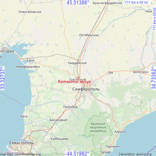
Komsomol’skoye GPS coordinates[2]
45° 1' 8.4" North, 34° 1' 49.764" East
| Map corner | latitude | longitude |
|---|---|---|
| Upper-left | 45.51386°, | 33.32737° |
| Center: | 45.019°, | 34.03049° |
| Lower-right: | 44.51982°, | 34.73362° |
| Map W x H: | 110.5×110.5 km | = 68.7×68.7mi |
| max Lat: | 52.18903° ⇑90.9% North |
| Komsomol’skoye: | 45.019° |
| min Lat: | ⇓9.1% South 44.39214° |
| min Long | Komsomol’skoy | max Long |
| 22.20555° | 34.03049° | 40.13222° |
| W 63.5%⇐ | ⇒36.5% E |
Elevation
Elevation of Komsomol’skoye is 191 m = 627 ft, and this is 35.2 m = 115 ft above average elevation for this country.
| Max E: |
886 m = 2907 ft | 33.6% |
| Komsomol’skoye | 191 m 627 ft | |
| Avg. | 155.8 m = 511 ft | |
Min E: |
-3 m = -10 ft | 66.4% |
See also: Ukraine elevation on elevation.city.
Geographical zone
Komsomol’skoye is located in North temperate zone (between Tropic of Cancer and the Arctic Circle). Distance of this North polar circle is 2395.5 km =1488.5 mi to North.| Distance of | km | miles | from Komsomol’skoye |
|---|---|---|---|
| North Pole | 5001.4 | 3107.7 | to North |
| Arctic Circle | 2395.5 | 1488.5 | to North |
| Tropic Cancer | 2399.7 | 1491.1 | to South |
| Equator | 5005.6 | 3110.3 | to South |


Nearby cities:
15 places around Komsomol’skoye: (largest is in red/bold)
• Aeroflotskiy
2.4 km =1.5 mi,  267°
267°
• Agrarnoye
2.1 km =1.3 mi,  99°
99°
• Beloglinka
2.8 km =1.7 mi,  161°
161°
• Chaykino
8.3 km =5.2 mi,  32°
32°
• Gresovskiy
1.3 km =0.8 mi,  194°
194°
• Kurgannoye
9.1 km =5.7 mi,  307°
307°
• Malen’koye
6.8 km =4.2 mi,  338°
338°
• Mirnoye
4.7 km =2.9 mi,  148°
148°
• Molodyozhnoye
2.7 km =1.7 mi,  130°
130°
• Rodnikovo
6.6 km =4.1 mi,  293°
293°
• Sofiivka
8.3 km =5.2 mi, 342°
• Solnechnoye
5.3 km =3.3 mi,  52°
52°
• Sovkhoznoye
2 km =1.2 mi, 309°
• Ukromnoye
3.4 km =2.1 mi,  320°
320°
• Urozhaynoye
8.7 km =5.4 mi,  70°
70°
Sources, notices
• [Note1] Compared only with cities in Ukraine existing in our database
• [Src1] Map data: © OpenStreetMap contributors (CC-BY-SA)
• [Src2] Other city data from geonames.org with taken over terms of usage.
• [Src3] Geographical zone / Annual Mean Temperature by Robert A. Rohde @ Wikipedia
