Malen’koye geodata
Malen’koye (Republic of Crimea) is a populated place; located in Ukraine in Europe/Simferopol (GMT+3) time zone. With population of 1,546 people, there are 1200 cities with bigger population in this country. Compared to other cities in Ukraine, 88.8% of cities are located further ↑North; 62.6% of cities are located further ←West and 58.8% of cities have lower elevation than Malen’koye. Note1
Administrative division(s):
- Level 1: Republic of Crimea
- Level 2: Simferopol Raion
- Level 3: Gvardeyskoye sel'skoye poselenye


Malen’koye GPS coordinates[2]
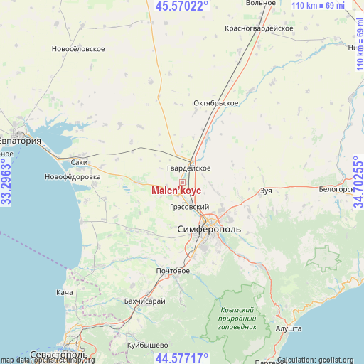
45° 4' 33.06" North, 33° 59' 57.912" East
| Map corner | latitude | longitude |
|---|---|---|
| Upper-left | 45.57022°, | 33.2963° |
| Center: | 45.07585°, | 33.99942° |
| Lower-right: | 44.57717°, | 34.70255° |
| Map W x H: | 110.4×110.4 km | = 68.6×68.6mi |
| max Lat: | 52.18903° ⇑88.8% North |
| Malen’koye: | 45.07585° |
| min Lat: | ⇓11.2% South 44.39214° |
| min Long | Malen’koye | max Long |
| 22.20555° | 33.99942° | 40.13222° |
| W 62.6%⇐ | ⇒37.4% E |
Elevation
Elevation of Malen’koye is 164 m = 538 ft, and this is 8.2 m = 27 ft above average elevation for this country.
| Max E: |
886 m = 2907 ft | 41.2% |
| Malen’koye | 164 m 538 ft | |
| Avg. | 155.8 m = 511 ft | |
Min E: |
-3 m = -10 ft | 58.8% |
See also: Ukraine elevation on elevation.city.
Geographical zone
Malen’koye is located in North temperate zone (between Tropic of Cancer and the Arctic Circle). Distance of this North polar circle is 2389.2 km =1484.6 mi to North.| Distance of | km | miles | from Malen’koye |
|---|---|---|---|
| North Pole | 4995.1 | 3103.8 | to North |
| Arctic Circle | 2389.2 | 1484.6 | to North |
| Tropic Cancer | 2406 | 1495 | to South |
| Equator | 5012 | 3114.3 | to South |


Nearby cities:
15 places around Malen’koye: (largest is in red/bold)
• Aeroflotskiy
6.4 km =4 mi,  179°
179°
• Agrarnoye
8.1 km =5 mi,  145°
145°
• Arkadyevka
8 km =5 mi,  236°
236°
• Chaykino
6.9 km =4.3 mi,  84°
84°
• Gresovskiy
7.8 km =4.8 mi,  164°
164°
• Hvardiiske
4.9 km =3 mi,  21°
21°
• Komsomol’skoye
6.8 km =4.2 mi, 158°
• Krasna Zor'ka
7.2 km =4.5 mi,  26°
26°
• Kurgannoye
4.8 km =3 mi,  260°
260°
• Pervomayskoye
6.5 km =4 mi,  51°
51°
• Rodnikovo
5.1 km =3.2 mi,  224°
224°
• Sofiivka
1.6 km =1 mi,  358°
358°
• Solnechnoye
7.3 km =4.5 mi,  115°
115°
• Sovkhoznoye
5.1 km =3.2 mi,  170°
170°
• Ukromnoye
3.7 km =2.3 mi, 175°
Sources, notices
• [Note1] Compared only with cities in Ukraine existing in our database
• [Src1] Map data: © OpenStreetMap contributors (CC-BY-SA)
• [Src2] Other city data from geonames.org with taken over terms of usage.
• [Src3] Geographical zone / Annual Mean Temperature by Robert A. Rohde @ Wikipedia
