Rodnikovo geodata
Rodnikovo (Republic of Crimea) is a seat of a third-order administrative division; located in Ukraine in Europe/Simferopol (GMT+3) time zone. With population of 3,492 people, there are 837 cities with bigger population in this country. Compared to other cities in Ukraine, 90.1% of cities are located further ↑North; 61.4% of cities are located further ←West and 57.2% of cities have lower elevation than Rodnikovo. Note1
Administrative division(s):
- Level 1: Republic of Crimea
- Level 2: Simferopol Raion
- Level 3: Rodnikovskoye sel'skoye poselenye


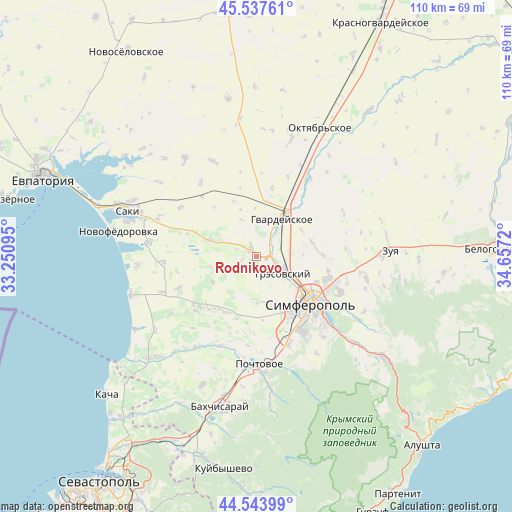
Rodnikovo GPS coordinates[2]
45° 2' 34.656" North, 33° 57' 14.652" East
| Map corner | latitude | longitude |
|---|---|---|
| Upper-left | 45.53761°, | 33.25095° |
| Center: | 45.04296°, | 33.95407° |
| Lower-right: | 44.54399°, | 34.6572° |
| Map W x H: | 110.5×110.5 km | = 68.7×68.7mi |
| max Lat: | 52.18903° ⇑90.1% North |
| Rodnikovo: | 45.04296° |
| min Lat: | ⇓9.9% South 44.39214° |
| min Long | Rodnikovo | max Long |
| 22.20555° | 33.95407° | 40.13222° |
| W 61.4%⇐ | ⇒38.6% E |
Elevation
Elevation of Rodnikovo is 159 m = 522 ft, and this is 3.2 m = 10 ft above average elevation for this country.
| Max E: |
886 m = 2907 ft | 42.8% |
| Rodnikovo | 159 m 522 ft | |
| Avg. | 155.8 m = 511 ft | |
Min E: |
-3 m = -10 ft | 57.2% |
See also: Ukraine elevation on elevation.city.
Geographical zone
Rodnikovo is located in North temperate zone (between Tropic of Cancer and the Arctic Circle). Distance of this North polar circle is 2392.9 km =1486.9 mi to North.| Distance of | km | miles | from Rodnikovo |
|---|---|---|---|
| North Pole | 4998.8 | 3106.1 | to North |
| Arctic Circle | 2392.9 | 1486.9 | to North |
| Tropic Cancer | 2402.4 | 1492.8 | to South |
| Equator | 5008.3 | 3112 | to South |


Nearby cities:
15 places around Rodnikovo: (largest is in red/bold)
• Aeroflotskiy
4.5 km =2.8 mi,  127°
127°
• Agrarnoye
8.6 km =5.3 mi,  110°
110°
• Arkadyevka
3.2 km =2 mi,  255°
255°
• Beloglinka
8.7 km =5.4 mi, 127°
• Gresovskiy
6.9 km =4.3 mi,  124°
124°
• Hvardiiske
9.8 km =6.1 mi,  32°
32°
• Kolodeznoye
9.9 km =6.2 mi, 256°
• Komsomol’skoye
6.6 km =4.1 mi, 113°
• Kurgannoye
3.1 km =1.9 mi,  337°
337°
• Malen’koye
5.1 km =3.2 mi,  44°
44°
• Molodyozhnoye
9.2 km =5.7 mi, 118°
• Shkol’noye
4.7 km =2.9 mi,  290°
290°
• Sofiivka
6.3 km =3.9 mi, 34°
• Sovkhoznoye
4.7 km =2.9 mi, 107°
• Ukromnoye
3.9 km =2.4 mi,  90°
90°
Sources, notices
• [Note1] Compared only with cities in Ukraine existing in our database
• [Src1] Map data: © OpenStreetMap contributors (CC-BY-SA)
• [Src2] Other city data from geonames.org with taken over terms of usage.
• [Src3] Geographical zone / Annual Mean Temperature by Robert A. Rohde @ Wikipedia
