Sovkhoznoye geodata
Sovkhoznoye (Republic of Crimea) is a populated place; located in Ukraine in Europe/Simferopol (GMT+3) time zone. With population of 1,109 people, there are 1331 cities with bigger population in this country. Compared to other cities in Ukraine, 90.4% of cities are located further ↑North; 63% of cities are located further ←West and 63.8% of cities have lower elevation than Sovkhoznoye. Note1
Administrative division(s):
- Level 1: Republic of Crimea
- Level 2: Simferopol Raion
- Level 3: Ukromnovskoye sel'skoye poselenye


Sovkhoznoye GPS coordinates[2]
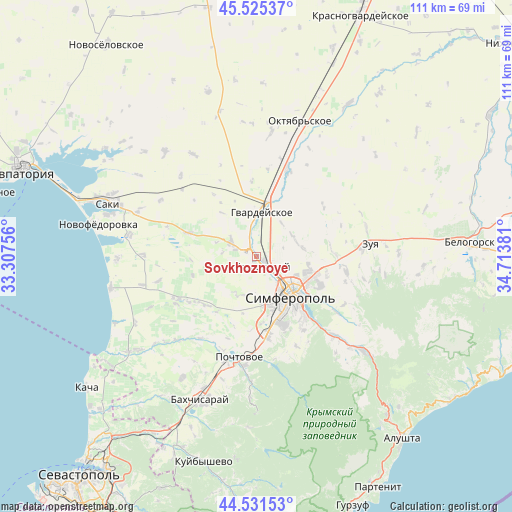
45° 1' 50.196" North, 34° 0' 38.448" East
| Map corner | latitude | longitude |
|---|---|---|
| Upper-left | 45.52537°, | 33.30756° |
| Center: | 45.03061°, | 34.01068° |
| Lower-right: | 44.53153°, | 34.71381° |
| Map W x H: | 110.5×110.5 km | = 68.7×68.7mi |
| max Lat: | 52.18903° ⇑90.4% North |
| Sovkhoznoye: | 45.03061° |
| min Lat: | ⇓9.6% South 44.39214° |
| min Long | Sovkhoznoye | max Long |
| 22.20555° | 34.01068° | 40.13222° |
| W 63%⇐ | ⇒37% E |
Elevation
Elevation of Sovkhoznoye is 182 m = 597 ft, and this is 26.2 m = 86 ft above average elevation for this country.
| Max E: |
886 m = 2907 ft | 36.2% |
| Sovkhoznoye | 182 m 597 ft | |
| Avg. | 155.8 m = 511 ft | |
Min E: |
-3 m = -10 ft | 63.8% |
See also: Ukraine elevation on elevation.city.
Geographical zone
Sovkhoznoye is located in North temperate zone (between Tropic of Cancer and the Arctic Circle). Distance of this North polar circle is 2394.2 km =1487.7 mi to North.| Distance of | km | miles | from Sovkhoznoye |
|---|---|---|---|
| North Pole | 5000.1 | 3106.9 | to North |
| Arctic Circle | 2394.2 | 1487.7 | to North |
| Tropic Cancer | 2401 | 1491.9 | to South |
| Equator | 5006.9 | 3111.1 | to South |


Nearby cities:
15 places around Sovkhoznoye: (largest is in red/bold)
• Aeroflotskiy
1.6 km =1 mi,  212°
212°
• Agrarnoye
4 km =2.5 mi,  113°
113°
• Arkadyevka
7.5 km =4.7 mi,  274°
274°
• Beloglinka
4.7 km =2.9 mi,  148°
148°
• Chaykino
8.3 km =5.2 mi,  46°
46°
• Gresovskiy
2.8 km =1.7 mi, 153°
• Komsomol’skoye
2 km =1.2 mi,  129°
129°
• Kurgannoye
7.1 km =4.4 mi,  307°
307°
• Malen’koye
5.1 km =3.2 mi,  350°
350°
• Mirnoye
6.6 km =4.1 mi,  142°
142°
• Molodyozhnoye
4.7 km =2.9 mi, 129°
• Rodnikovo
4.7 km =2.9 mi,  287°
287°
• Sofiivka
6.7 km =4.2 mi, 351°
• Solnechnoye
6.1 km =3.8 mi,  71°
71°
• Ukromnoye
1.5 km =0.9 mi,  336°
336°
Sources, notices
• [Note1] Compared only with cities in Ukraine existing in our database
• [Src1] Map data: © OpenStreetMap contributors (CC-BY-SA)
• [Src2] Other city data from geonames.org with taken over terms of usage.
• [Src3] Geographical zone / Annual Mean Temperature by Robert A. Rohde @ Wikipedia
