Aeroflotskiy geodata
Aeroflotskiy (Republic of Crimea) is a populated place; located in Ukraine in Europe/Simferopol (GMT+3) time zone. With population of 1,768 people, there are 1154 cities with bigger population in this country. Compared to other cities in Ukraine, 91% of cities are located further ↑North; 62.6% of cities are located further ←West and 69.5% of cities have lower elevation than Aeroflotskiy. Note1


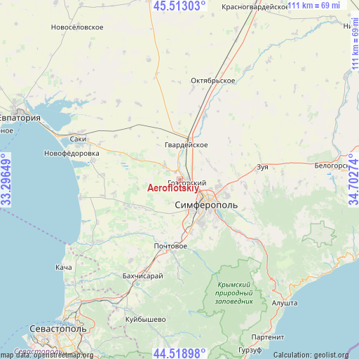
Aeroflotskiy GPS coordinates[2]
45° 1' 5.376" North, 33° 59' 58.596" East
| Map corner | latitude | longitude |
|---|---|---|
| Upper-left | 45.51303°, | 33.29649° |
| Center: | 45.01816°, | 33.99961° |
| Lower-right: | 44.51898°, | 34.70274° |
| Map W x H: | 110.5×110.5 km | = 68.7×68.7mi |
| max Lat: | 52.18903° ⇑91% North |
| Aeroflotskiy: | 45.01816° |
| min Lat: | ⇓9% South 44.39214° |
| min Long | Aeroflotskiy | max Long |
| 22.20555° | 33.99961° | 40.13222° |
| W 62.6%⇐ | ⇒37.4% E |
Elevation
Elevation of Aeroflotskiy is 204 m = 669 ft, and this is 48.2 m = 158 ft above average elevation for this country.
| Max E: |
886 m = 2907 ft | 30.5% |
| Aeroflotskiy | 204 m 669 ft | |
| Avg. | 155.8 m = 511 ft | |
Min E: |
-3 m = -10 ft | 69.5% |
See also: Ukraine elevation on elevation.city.
Geographical zone
Aeroflotskiy is located in North temperate zone (between Tropic of Cancer and the Arctic Circle). Distance of this North polar circle is 2395.6 km =1488.6 mi to North.| Distance of | km | miles | from Aeroflotskiy |
|---|---|---|---|
| North Pole | 5001.5 | 3107.8 | to North |
| Arctic Circle | 2395.6 | 1488.6 | to North |
| Tropic Cancer | 2399.6 | 1491 | to South |
| Equator | 5005.6 | 3110.3 | to South |


Nearby cities:
15 places around Aeroflotskiy: (largest is in red/bold)
• Agrarnoye
4.5 km =2.8 mi,  93°
93°
• Arkadyevka
6.9 km =4.3 mi,  286°
286°
• Beloglinka
4.2 km =2.6 mi,  128°
128°
• Gresovskiy
2.4 km =1.5 mi,  117°
117°
• Komsomol’skoye
2.4 km =1.5 mi, 87°
• Kurgannoye
7.4 km =4.6 mi,  319°
319°
• Malen’koye
6.4 km =4 mi,  359°
359°
• Mirnoye
6.2 km =3.9 mi, 128°
• Molodyozhnoye
4.7 km =2.9 mi,  110°
110°
• Rodnikovo
4.5 km =2.8 mi,  307°
307°
• Shkol’noye
9.2 km =5.7 mi,  298°
298°
• Sofiivka
8 km =5 mi, 359°
• Solnechnoye
7.4 km =4.6 mi,  63°
63°
• Sovkhoznoye
1.6 km =1 mi,  32°
32°
• Ukromnoye
2.7 km =1.7 mi,  5°
5°
Sources, notices
• [Note1] Compared only with cities in Ukraine existing in our database
• [Src1] Map data: © OpenStreetMap contributors (CC-BY-SA)
• [Src2] Other city data from geonames.org with taken over terms of usage.
• [Src3] Geographical zone / Annual Mean Temperature by Robert A. Rohde @ Wikipedia
