Pakharevka geodata
Pakharevka (Republic of Crimea) is a seat of a third-order administrative division; located in Ukraine in Europe/Simferopol (GMT+3) time zone. With population of 1,161 people, there are 1308 cities with bigger population in this country. Compared to other cities in Ukraine, 71.4% of cities are located further ↑North; 66.8% of cities are located further ←West and 89% of cities have higher elevation than Pakharevka. Note1
Administrative division(s):
- Level 1: Republic of Crimea
- Level 2: Dzhankoyskiy rayon
- Level 3: Pakharevskoye sel'skoye poselenye


Pakharevka GPS coordinates[2]
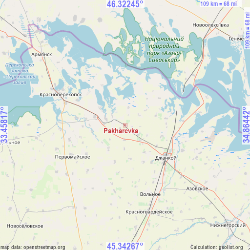
45° 50' 4.992" North, 34° 9' 40.644" East
| Map corner | latitude | longitude |
|---|---|---|
| Upper-left | 46.32245°, | 33.45817° |
| Center: | 45.83472°, | 34.16129° |
| Lower-right: | 45.34267°, | 34.86442° |
| Map W x H: | 108.9×108.9 km | = 67.7×67.7mi |
| max Lat: | 52.18903° ⇑71.4% North |
| Pakharevka: | 45.83472° |
| min Lat: | ⇓28.6% South 44.39214° |
| min Long | Pakharevka | max Long |
| 22.20555° | 34.16129° | 40.13222° |
| W 66.8%⇐ | ⇒33.2% E |
Elevation
Elevation of Pakharevka is 20 m = 66 ft, and this is 135.8 m = 446 ft below average elevation for this country.
| Max E: |
886 m = 2907 ft | 89% |
| Avg. | 155.8 m = 511 ft | |
| Pakharevka | 20 m = 66 ft | |
Min E: |
-3 m = -10 ft | 11% |
See also: Ukraine elevation on elevation.city.
Geographical zone
Pakharevka is located in North temperate zone (between Tropic of Cancer and the Arctic Circle). Distance of this North polar circle is 2304.8 km =1432.1 mi to North.| Distance of | km | miles | from Pakharevka |
|---|---|---|---|
| North Pole | 4910.7 | 3051.4 | to North |
| Arctic Circle | 2304.8 | 1432.1 | to North |
| Tropic Cancer | 2490.4 | 1547.5 | to South |
| Equator | 5096.3 | 3166.7 | to South |


Nearby cities:
15 places around Pakharevka: (largest is in red/bold)
• Istochnoye
13.1 km =8.1 mi,  307°
307°
• Krymka
14.6 km =9.1 mi,  171°
171°
• Lobanovo
9.1 km =5.7 mi,  136°
136°
• Luganskoye
7 km =4.3 mi,  121°
121°
• Magazinka
9.2 km =5.7 mi,  290°
290°
• Martynovka
13.8 km =8.6 mi,  72°
72°
• Mar’ino
14.4 km =8.9 mi, 144°
• Maslovo
16.3 km =10.1 mi,  106°
106°
• Novoivanovka
9.3 km =5.8 mi,  273°
273°
• Novokrymskoye
6.1 km =3.8 mi,  184°
184°
• Orlovskoye
14.8 km =9.2 mi,  259°
259°
• Ostrovskoye
12.7 km =7.9 mi,  215°
215°
• Ovoshchnoye
16.3 km =10.1 mi, 122°
• Tselinnoye
8.1 km =5 mi,  10°
10°
• Voinka
13.7 km =8.5 mi, 286°
Sources, notices
• [Note1] Compared only with cities in Ukraine existing in our database
• [Src1] Map data: © OpenStreetMap contributors (CC-BY-SA)
• [Src2] Other city data from geonames.org with taken over terms of usage.
• [Src3] Geographical zone / Annual Mean Temperature by Robert A. Rohde @ Wikipedia
