Voinka geodata
Voinka (Republic of Crimea) is a seat of a third-order administrative division; located in Ukraine in Europe/Simferopol (GMT+3) time zone. With population of 4,089 people, there are 751 cities with bigger population in this country. Compared to other cities in Ukraine, 70.9% of cities are located further ↑North; 62.2% of cities are located further ←West and 94.4% of cities have higher elevation than Voinka. Note1
Administrative division(s):
- Level 1: Republic of Crimea
- Level 2: Krasnoperekopsk Raion
- Level 3: Voinskoye sel'skoye poselenye


Voinka GPS coordinates[2]
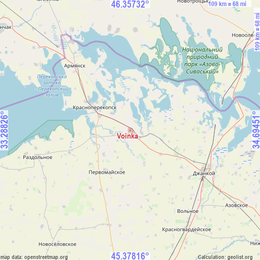
45° 52' 11.64" North, 33° 59' 28.968" East
| Map corner | latitude | longitude |
|---|---|---|
| Upper-left | 46.35732°, | 33.28826° |
| Center: | 45.8699°, | 33.99138° |
| Lower-right: | 45.37816°, | 34.69451° |
| Map W x H: | 108.9×108.9 km | = 67.7×67.7mi |
| max Lat: | 52.18903° ⇑70.9% North |
| Voinka: | 45.8699° |
| min Lat: | ⇓29.1% South 44.39214° |
| min Long | Voinka | max Long |
| 22.20555° | 33.99138° | 40.13222° |
| W 62.2%⇐ | ⇒37.8% E |
Elevation
Elevation of Voinka is 13 m = 43 ft, and this is 142.8 m = 469 ft below average elevation for this country.
| Max E: |
886 m = 2907 ft | 94.4% |
| Avg. | 155.8 m = 511 ft | |
| Voinka | 13 m = 43 ft | |
Min E: |
-3 m = -10 ft | 5.6% |
See also: Ukraine elevation on elevation.city.
Geographical zone
Voinka is located in North temperate zone (between Tropic of Cancer and the Arctic Circle). Distance of this North polar circle is 2300.9 km =1429.7 mi to North.| Distance of | km | miles | from Voinka |
|---|---|---|---|
| North Pole | 4906.8 | 3048.9 | to North |
| Arctic Circle | 2300.9 | 1429.7 | to North |
| Tropic Cancer | 2494.3 | 1549.9 | to South |
| Equator | 5100.3 | 3169.2 | to South |


Nearby cities:
15 places around Voinka: (largest is in red/bold)
• Bratskoye
6.9 km =4.3 mi,  231°
231°
• Dolinka
4 km =2.5 mi,  256°
256°
• Ishun’
14.3 km =8.9 mi,  294°
294°
• Istochnoye
4.8 km =3 mi,  33°
33°
• Krasnoarmeyskoye
13.8 km =8.6 mi,  12°
12°
• Magazinka
4.6 km =2.9 mi,  99°
99°
• Novoivanovka
5.2 km =3.2 mi,  130°
130°
• Novopavlovka
7.8 km =4.8 mi,  267°
267°
• Orlovskoye
6.7 km =4.2 mi,  192°
192°
• Ostrovskoye
15.3 km =9.5 mi,  157°
157°
• Pakharevka
13.7 km =8.5 mi,  106°
106°
• Pravda
15.1 km =9.4 mi, 228°
• Tselinnoye
15.2 km =9.4 mi,  74°
74°
• Vishnyovka
10.4 km =6.5 mi,  343°
343°
• Zelyonaya Niva
10.6 km =6.6 mi,  313°
313°
Sources, notices
• [Note1] Compared only with cities in Ukraine existing in our database
• [Src1] Map data: © OpenStreetMap contributors (CC-BY-SA)
• [Src2] Other city data from geonames.org with taken over terms of usage.
• [Src3] Geographical zone / Annual Mean Temperature by Robert A. Rohde @ Wikipedia
