Istochnoye geodata
Istochnoye (Republic of Crimea) is a populated place; located in Ukraine in Europe/Simferopol (GMT+3) time zone. With population of 723 people, there are 1523 cities with bigger population in this country. Compared to other cities in Ukraine, 70.6% of cities are located further ↑North; 63.4% of cities are located further ←West and 99% of cities have higher elevation than Istochnoye. Note1
Administrative division(s):
- Level 1: Republic of Crimea
- Level 2: Krasnoperekopsk Raion
- Level 3: Voinskoye sel'skoye poselenye


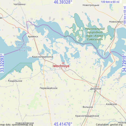
Istochnoye GPS coordinates[2]
45° 54' 22.248" North, 34° 1' 33.78" East
| Map corner | latitude | longitude |
|---|---|---|
| Upper-left | 46.39328°, | 33.32293° |
| Center: | 45.90618°, | 34.02605° |
| Lower-right: | 45.41476°, | 34.72918° |
| Map W x H: | 108.8×108.8 km | = 67.6×67.6mi |
| max Lat: | 52.18903° ⇑70.6% North |
| Istochnoye: | 45.90618° |
| min Lat: | ⇓29.4% South 44.39214° |
| min Long | Istochnoye | max Long |
| 22.20555° | 34.02605° | 40.13222° |
| W 63.4%⇐ | ⇒36.6% E |
Elevation
Elevation of Istochnoye is 5 m = 16 ft, and this is 150.8 m = 495 ft below average elevation for this country.
| Max E: |
886 m = 2907 ft | 99% |
| Avg. | 155.8 m = 511 ft | |
| Istochnoye | 5 m = 16 ft | |
Min E: |
-3 m = -10 ft | 1% |
See also: Ukraine elevation on elevation.city.
Geographical zone
Istochnoye is located in North temperate zone (between Tropic of Cancer and the Arctic Circle). Distance of this North polar circle is 2296.9 km =1427.2 mi to North.| Distance of | km | miles | from Istochnoye |
|---|---|---|---|
| North Pole | 4902.8 | 3046.5 | to North |
| Arctic Circle | 2296.9 | 1427.2 | to North |
| Tropic Cancer | 2498.4 | 1552.4 | to South |
| Equator | 5104.3 | 3171.7 | to South |


Nearby cities:
15 places around Istochnoye: (largest is in red/bold)
• Bratskoye
11.6 km =7.2 mi,  224°
224°
• Dolinka
8.2 km =5.1 mi,  233°
233°
• Ishun’
15.8 km =9.8 mi,  277°
277°
• Krasnoarmeyskoye
9.4 km =5.8 mi,  2°
2°
• Magazinka
5.1 km =3.2 mi,  159°
159°
• Novoivanovka
7.5 km =4.7 mi,  170°
170°
• Novokrymskoye
17.2 km =10.7 mi,  144°
144°
• Novopavlovka
11.4 km =7.1 mi,  247°
247°
• Orlovskoye
11.4 km =7.1 mi,  201°
201°
• Ostrovskoye
18.5 km =11.5 mi, 170°
• Pakharevka
13.1 km =8.1 mi,  127°
127°
• Tselinnoye
12 km =7.5 mi,  89°
89°
• Vishnyovka
8.2 km =5.1 mi,  316°
316°
• Voinka
4.8 km =3 mi,  213°
213°
• Zelyonaya Niva
10.9 km =6.8 mi,  287°
287°
Sources, notices
• [Note1] Compared only with cities in Ukraine existing in our database
• [Src1] Map data: © OpenStreetMap contributors (CC-BY-SA)
• [Src2] Other city data from geonames.org with taken over terms of usage.
• [Src3] Geographical zone / Annual Mean Temperature by Robert A. Rohde @ Wikipedia
