Geroyskoye geodata
Geroyskoye (Republic of Crimea) is a seat of a third-order administrative division; located in Ukraine in Europe/Simferopol (GMT+3) time zone. With population of 1,740 people, there are 1161 cities with bigger population in this country. Compared to other cities in Ukraine, 87.2% of cities are located further ↑North; 56.4% of cities are located further ←West and 80.6% of cities have higher elevation than Geroyskoye. Note1
Administrative division(s):
- Level 1: Republic of Crimea
- Level 2: Sakskiy rayon
- Level 3: Geroyskoye sel'skoye poselenye


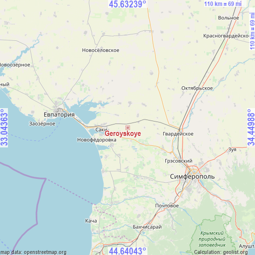
Geroyskoye GPS coordinates[2]
45° 8' 18.852" North, 33° 44' 48.3" East
| Map corner | latitude | longitude |
|---|---|---|
| Upper-left | 45.63239°, | 33.04363° |
| Center: | 45.13857°, | 33.74675° |
| Lower-right: | 44.64043°, | 34.44988° |
| Map W x H: | 110.3×110.3 km | = 68.5×68.5mi |
| max Lat: | 52.18903° ⇑87.2% North |
| Geroyskoye: | 45.13857° |
| min Lat: | ⇓12.8% South 44.39214° |
| min Long | Geroyskoye | max Long |
| 22.20555° | 33.74675° | 40.13222° |
| W 56.4%⇐ | ⇒43.6% E |
Elevation
Elevation of Geroyskoye is 41 m = 135 ft, and this is 114.8 m = 377 ft below average elevation for this country.
| Max E: |
886 m = 2907 ft | 80.6% |
| Avg. | 155.8 m = 511 ft | |
| Geroyskoye | 41 m = 135 ft | |
Min E: |
-3 m = -10 ft | 19.4% |
See also: Ukraine elevation on elevation.city.
Geographical zone
Geroyskoye is located in North temperate zone (between Tropic of Cancer and the Arctic Circle). Distance of this North polar circle is 2382.2 km =1480.2 mi to North.| Distance of | km | miles | from Geroyskoye |
|---|---|---|---|
| North Pole | 4988.1 | 3099.5 | to North |
| Arctic Circle | 2382.2 | 1480.2 | to North |
| Tropic Cancer | 2413 | 1499.4 | to South |
| Equator | 5018.9 | 3118.6 | to South |


Nearby cities:
15 places around Geroyskoye: (largest is in red/bold)
• Chervonoye
5 km =3.1 mi,  249°
249°
• Dolinka
13.3 km =8.3 mi,  330°
330°
• Ivanovka
10 km =6.2 mi,  222°
222°
• Krayneye
12.2 km =7.6 mi,  33°
33°
• Krymskoye
7 km =4.3 mi,  37°
37°
• Lesnovka
10.2 km =6.3 mi,  279°
279°
• Mikhaylovka
11 km =6.8 mi,  255°
255°
• Mityayevo
11.2 km =7 mi,  341°
341°
• Orekhovo
9.1 km =5.7 mi, 263°
• Saki
11.5 km =7.1 mi,  267°
267°
• Shelkovichnoye
7.1 km =4.4 mi,  319°
319°
• Skvortsovo
9.1 km =5.7 mi,  140°
140°
• Teplovka
12.5 km =7.8 mi,  198°
198°
• Trudovoye
11.1 km =6.9 mi,  4°
4°
• Yarkoye
5.2 km =3.2 mi,  62°
62°
Sources, notices
• [Note1] Compared only with cities in Ukraine existing in our database
• [Src1] Map data: © OpenStreetMap contributors (CC-BY-SA)
• [Src2] Other city data from geonames.org with taken over terms of usage.
• [Src3] Geographical zone / Annual Mean Temperature by Robert A. Rohde @ Wikipedia
