Skvortsovo geodata
Skvortsovo (Republic of Crimea) is a seat of a third-order administrative division; located in Ukraine in Europe/Simferopol (GMT+3) time zone. With population of 2,517 people, there are 1034 cities with bigger population in this country. Compared to other cities in Ukraine, 88.9% of cities are located further ↑North; 58.4% of cities are located further ←West and 76.1% of cities have higher elevation than Skvortsovo. Note1
Administrative division(s):
- Level 1: Republic of Crimea
- Level 2: Simferopol Raion
- Level 3: Skvortsovskoye sel'skoye poselenye


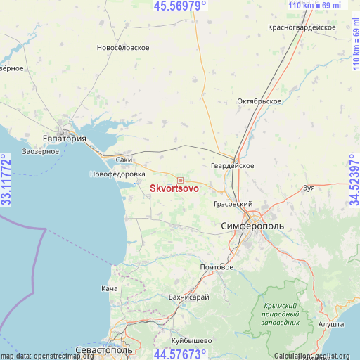
Skvortsovo GPS coordinates[2]
45° 4' 31.512" North, 33° 49' 15.024" East
| Map corner | latitude | longitude |
|---|---|---|
| Upper-left | 45.56979°, | 33.11772° |
| Center: | 45.07542°, | 33.82084° |
| Lower-right: | 44.57673°, | 34.52397° |
| Map W x H: | 110.4×110.4 km | = 68.6×68.6mi |
| max Lat: | 52.18903° ⇑88.9% North |
| Skvortsovo: | 45.07542° |
| min Lat: | ⇓11.1% South 44.39214° |
| min Long | Skvortsovo | max Long |
| 22.20555° | 33.82084° | 40.13222° |
| W 58.4%⇐ | ⇒41.6% E |
Elevation
Elevation of Skvortsovo is 57 m = 187 ft, and this is 98.8 m = 324 ft below average elevation for this country.
| Max E: |
886 m = 2907 ft | 76.1% |
| Avg. | 155.8 m = 511 ft | |
| Skvortsovo | 57 m = 187 ft | |
Min E: |
-3 m = -10 ft | 23.9% |
See also: Ukraine elevation on elevation.city.
Geographical zone
Skvortsovo is located in North temperate zone (between Tropic of Cancer and the Arctic Circle). Distance of this North polar circle is 2389.3 km =1484.6 mi to North.| Distance of | km | miles | from Skvortsovo |
|---|---|---|---|
| North Pole | 4995.1 | 3103.8 | to North |
| Arctic Circle | 2389.3 | 1484.6 | to North |
| Tropic Cancer | 2406 | 1495 | to South |
| Equator | 5011.9 | 3114.2 | to South |


Nearby cities:
15 places around Skvortsovo: (largest is in red/bold)
• Arkadyevka
8.6 km =5.3 mi,  120°
120°
• Chervonoye
11.8 km =7.3 mi,  296°
296°
• Geroyskoye
9.1 km =5.7 mi,  320°
320°
• Ivanovka
12.5 km =7.8 mi,  268°
268°
• Kolodeznoye
6 km =3.7 mi,  171°
171°
• Krymskoye
12.7 km =7.9 mi,  352°
352°
• Kurgannoye
9.3 km =5.8 mi,  94°
94°
• Malen’koye
14 km =8.7 mi, 89°
• Novosyolovka
9.1 km =5.7 mi, 172°
• Rodnikovo
11.1 km =6.9 mi,  109°
109°
• Shkol’noye
6.3 km =3.9 mi, 108°
• Sofiivka
14.1 km =8.8 mi,  83°
83°
• Teplovka
10.9 km =6.8 mi,  244°
244°
• Vinnitskoye
12.3 km =7.6 mi,  211°
211°
• Yarkoye
9.5 km =5.9 mi, 352°
Sources, notices
• [Note1] Compared only with cities in Ukraine existing in our database
• [Src1] Map data: © OpenStreetMap contributors (CC-BY-SA)
• [Src2] Other city data from geonames.org with taken over terms of usage.
• [Src3] Geographical zone / Annual Mean Temperature by Robert A. Rohde @ Wikipedia
