Yarkoye Pole geodata
Yarkoye Pole (Republic of Crimea) is a seat of a third-order administrative division; located in Ukraine in Europe/Simferopol (GMT+3) time zone. With population of 4,914 people, there are 661 cities with bigger population in this country. Compared to other cities in Ukraine, 85.6% of cities are located further ↑North; 82.3% of cities are located further ←West and 84.8% of cities have higher elevation than Yarkoye Pole. Note1
Administrative division(s):
- Level 1: Republic of Crimea
- Level 2: Kirovske Raion
- Level 3: Yarkopolenskoye sel'skoye poselenye


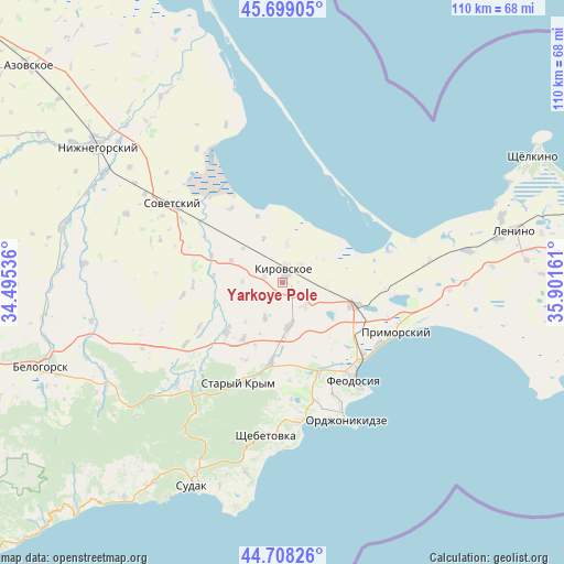
Yarkoye Pole GPS coordinates[2]
45° 12' 20.916" North, 35° 11' 54.528" East
| Map corner | latitude | longitude |
|---|---|---|
| Upper-left | 45.69905°, | 34.49536° |
| Center: | 45.20581°, | 35.19848° |
| Lower-right: | 44.70826°, | 35.90161° |
| Map W x H: | 110.2×110.2 km | = 68.5×68.5mi |
| max Lat: | 52.18903° ⇑85.6% North |
| Yarkoye Pole: | 45.20581° |
| min Lat: | ⇓14.4% South 44.39214° |
| min Long | Yarkoye Pole | max Long |
| 22.20555° | 35.19848° | 40.13222° |
| W 82.3%⇐ | ⇒17.7% E |
Elevation
Elevation of Yarkoye Pole is 30 m = 98 ft, and this is 125.8 m = 413 ft below average elevation for this country.
| Max E: |
886 m = 2907 ft | 84.8% |
| Avg. | 155.8 m = 511 ft | |
| Yarkoye Pole | 30 m = 98 ft | |
Min E: |
-3 m = -10 ft | 15.2% |
See also: Ukraine elevation on elevation.city.
Geographical zone
Yarkoye Pole is located in North temperate zone (between Tropic of Cancer and the Arctic Circle). Distance of this North polar circle is 2374.8 km =1475.6 mi to North.| Distance of | km | miles | from Yarkoye Pole |
|---|---|---|---|
| North Pole | 4980.6 | 3094.8 | to North |
| Arctic Circle | 2374.8 | 1475.6 | to North |
| Tropic Cancer | 2420.5 | 1504 | to South |
| Equator | 5026.4 | 3123.3 | to South |


Nearby cities:
15 places around Yarkoye Pole: (largest is in red/bold)
• Abrikosovka
13.3 km =8.3 mi,  214°
214°
• Babenkovo
13.2 km =8.2 mi,  203°
203°
• Ilyichevo
10.9 km =6.8 mi,  293°
293°
• Kirovskoye
2.7 km =1.7 mi,  2°
2°
• Novopokrovka
6.2 km =3.9 mi,  136°
136°
• Partizany
7.7 km =4.8 mi, 206°
• Privetnoye
14.5 km =9 mi,  228°
228°
• Shubino
7.6 km =4.7 mi,  8°
8°
• Sinitsyno
5.2 km =3.2 mi,  45°
45°
• Tokarevo
9.4 km =5.8 mi,  337°
337°
• Trudolyubovka
3.8 km =2.4 mi, 289°
• Vladislavovka
14.6 km =9.1 mi,  106°
106°
• Vostochnoye
13.5 km =8.4 mi,  276°
276°
• Vozrozhdeniye
13.5 km =8.4 mi,  254°
254°
• Zhuravki
8.9 km =5.5 mi,  171°
171°
Sources, notices
• [Note1] Compared only with cities in Ukraine existing in our database
• [Src1] Map data: © OpenStreetMap contributors (CC-BY-SA)
• [Src2] Other city data from geonames.org with taken over terms of usage.
• [Src3] Geographical zone / Annual Mean Temperature by Robert A. Rohde @ Wikipedia
