Vladislavovka geodata
Vladislavovka (Republic of Crimea) is a seat of a third-order administrative division; located in Ukraine in Europe/Simferopol (GMT+3) time zone. With population of 3,324 people, there are 865 cities with bigger population in this country. Compared to other cities in Ukraine, 86.5% of cities are located further ↑North; 84% of cities are located further ←West and 82.5% of cities have higher elevation than Vladislavovka. Note1
Administrative division(s):
- Level 1: Republic of Crimea
- Level 2: Kirovske Raion
- Level 3: Vladislavovskoye sel'skoye poselenye


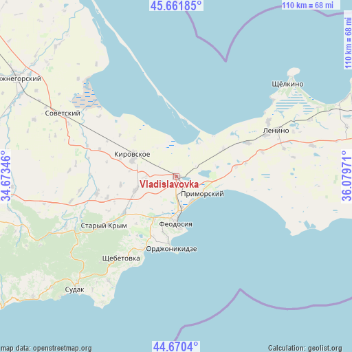
Vladislavovka GPS coordinates[2]
45° 10' 5.808" North, 35° 22' 35.688" East
| Map corner | latitude | longitude |
|---|---|---|
| Upper-left | 45.66185°, | 34.67346° |
| Center: | 45.16828°, | 35.37658° |
| Lower-right: | 44.6704°, | 36.07971° |
| Map W x H: | 110.2×110.2 km | = 68.5×68.5mi |
| max Lat: | 52.18903° ⇑86.5% North |
| Vladislavovka: | 45.16828° |
| min Lat: | ⇓13.5% South 44.39214° |
| min Long | Vladislavovka | max Long |
| 22.20555° | 35.37658° | 40.13222° |
| W 84%⇐ | ⇒16% E |
Elevation
Elevation of Vladislavovka is 37 m = 121 ft, and this is 118.8 m = 390 ft below average elevation for this country.
| Max E: |
886 m = 2907 ft | 82.5% |
| Avg. | 155.8 m = 511 ft | |
| Vladislavovka | 37 m = 121 ft | |
Min E: |
-3 m = -10 ft | 17.5% |
See also: Ukraine elevation on elevation.city.
Geographical zone
Vladislavovka is located in North temperate zone (between Tropic of Cancer and the Arctic Circle). Distance of this North polar circle is 2378.9 km =1478.2 mi to North.| Distance of | km | miles | from Vladislavovka |
|---|---|---|---|
| North Pole | 4984.8 | 3097.4 | to North |
| Arctic Circle | 2378.9 | 1478.2 | to North |
| Tropic Cancer | 2416.3 | 1501.4 | to South |
| Equator | 5022.2 | 3120.6 | to South |


Nearby cities:
15 places around Vladislavovka: (largest is in red/bold)
• Beregovoye
9.3 km =5.8 mi,  151°
151°
• Blizhneye
12.9 km =8 mi,  196°
196°
• Feodosiya
14.6 km =9.1 mi,  179°
179°
• Kirovskoye
15.4 km =9.6 mi,  296°
296°
• Nasypnoe
14.4 km =8.9 mi,  206°
206°
• Novopokrovka
9.7 km =6 mi,  267°
267°
• Partizany
17.6 km =10.9 mi,  261°
261°
• Primorskiy
9.8 km =6.1 mi,  123°
123°
• Semisotka
17.1 km =10.6 mi,  59°
59°
• Shubino
17.4 km =10.8 mi,  312°
312°
• Sinitsyno
12.8 km =8 mi, 307°
• Solnechnoye
13.7 km =8.5 mi,  190°
190°
• Trudolyubovka
18.4 km =11.4 mi,  287°
287°
• Yarkoye Pole
14.6 km =9.1 mi, 286°
• Zhuravki
13.5 km =8.4 mi,  249°
249°
Sources, notices
• [Note1] Compared only with cities in Ukraine existing in our database
• [Src1] Map data: © OpenStreetMap contributors (CC-BY-SA)
• [Src2] Other city data from geonames.org with taken over terms of usage.
• [Src3] Geographical zone / Annual Mean Temperature by Robert A. Rohde @ Wikipedia
