Vostochnoye geodata
Vostochnoye (Republic of Crimea) is a populated place; located in Ukraine in Europe/Simferopol (GMT+3) time zone. With population of 592 people, there are 1589 cities with bigger population in this country. Compared to other cities in Ukraine, 85.3% of cities are located further ↑North; 80.6% of cities are located further ←West and 76.7% of cities have higher elevation than Vostochnoye. Note1
Administrative division(s):
- Level 1: Republic of Crimea
- Level 2: Sovietskyi Raion
- Level 3: Ilyichovskoye sel'skoye poselenye


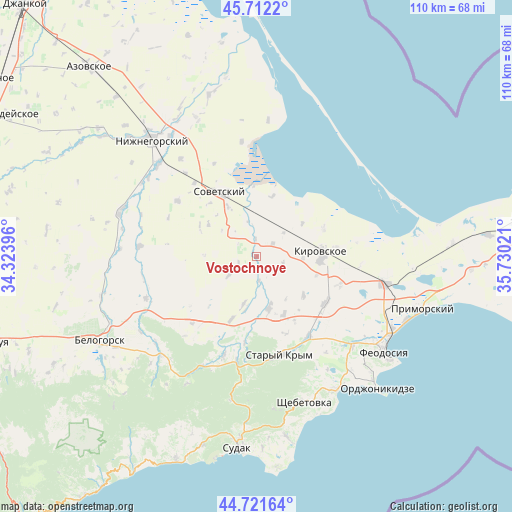
Vostochnoye GPS coordinates[2]
45° 13' 8.688" North, 35° 1' 37.488" East
| Map corner | latitude | longitude |
|---|---|---|
| Upper-left | 45.7122°, | 34.32396° |
| Center: | 45.21908°, | 35.02708° |
| Lower-right: | 44.72164°, | 35.73021° |
| Map W x H: | 110.1×110.1 km | = 68.4×68.4mi |
| max Lat: | 52.18903° ⇑85.3% North |
| Vostochnoye: | 45.21908° |
| min Lat: | ⇓14.7% South 44.39214° |
| min Long | Vostochnoye | max Long |
| 22.20555° | 35.02708° | 40.13222° |
| W 80.6%⇐ | ⇒19.4% E |
Elevation
Elevation of Vostochnoye is 54 m = 177 ft, and this is 101.8 m = 334 ft below average elevation for this country.
| Max E: |
886 m = 2907 ft | 76.7% |
| Avg. | 155.8 m = 511 ft | |
| Vostochnoye | 54 m = 177 ft | |
Min E: |
-3 m = -10 ft | 23.3% |
See also: Ukraine elevation on elevation.city.
Geographical zone
Vostochnoye is located in North temperate zone (between Tropic of Cancer and the Arctic Circle). Distance of this North polar circle is 2373.3 km =1474.7 mi to North.| Distance of | km | miles | from Vostochnoye |
|---|---|---|---|
| North Pole | 4979.2 | 3093.9 | to North |
| Arctic Circle | 2373.3 | 1474.7 | to North |
| Tropic Cancer | 2422 | 1505 | to South |
| Equator | 5027.9 | 3124.2 | to South |


Nearby cities:
15 places around Vostochnoye: (largest is in red/bold)
• Abrikosovka
13.7 km =8.5 mi,  154°
154°
• Chapayevka
12.5 km =7.8 mi,  303°
303°
• Ilyichevo
4.5 km =2.8 mi,  49°
49°
• Kirovskoye
13.6 km =8.5 mi,  85°
85°
• Krasnoflotskoye
12.4 km =7.7 mi,  329°
329°
• Krasnogvardeyskoye
7.2 km =4.5 mi,  236°
236°
• Partizany
13.1 km =8.1 mi,  129°
129°
• Privetnoye
11.3 km =7 mi,  167°
167°
• Pushkino
4.3 km =2.7 mi,  246°
246°
• Tokarevo
12.2 km =7.6 mi, 53°
• Trudolyubovka
9.8 km =6.1 mi, 91°
• Urozhaynoye
13.4 km =8.3 mi,  14°
14°
• Vozrozhdeniye
5.1 km =3.2 mi,  175°
175°
• Yarkoye Pole
13.5 km =8.4 mi,  96°
96°
• Zolotoye Pole
10.5 km =6.5 mi,  195°
195°
Sources, notices
• [Note1] Compared only with cities in Ukraine existing in our database
• [Src1] Map data: © OpenStreetMap contributors (CC-BY-SA)
• [Src2] Other city data from geonames.org with taken over terms of usage.
• [Src3] Geographical zone / Annual Mean Temperature by Robert A. Rohde @ Wikipedia
