Svetloye geodata
Svetloye (Republic of Crimea) is a seat of a third-order administrative division; located in Ukraine in Europe/Simferopol (GMT+3) time zone. With population of 1,608 people, there are 1189 cities with bigger population in this country. Compared to other cities in Ukraine, 74.8% of cities are located further ↑North; 75.8% of cities are located further ←West and 90.9% of cities have higher elevation than Svetloye. Note1
Administrative division(s):
- Level 1: Republic of Crimea
- Level 2: Dzhankoyskiy rayon
- Level 3: Svetlovskoye sel'skoye poselenye


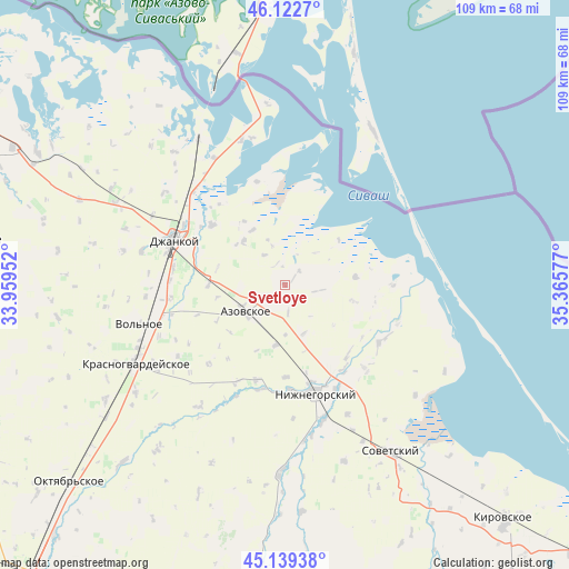
Svetloye GPS coordinates[2]
45° 37' 59.52" North, 34° 39' 45.504" East
| Map corner | latitude | longitude |
|---|---|---|
| Upper-left | 46.1227°, | 33.95952° |
| Center: | 45.6332°, | 34.66264° |
| Lower-right: | 45.13938°, | 35.36577° |
| Map W x H: | 109.3×109.3 km | = 67.9×67.9mi |
| max Lat: | 52.18903° ⇑74.8% North |
| Svetloye: | 45.6332° |
| min Lat: | ⇓25.2% South 44.39214° |
| min Long | Svetloye | max Long |
| 22.20555° | 34.66264° | 40.13222° |
| W 75.8%⇐ | ⇒24.2% E |
Elevation
Elevation of Svetloye is 18 m = 59 ft, and this is 137.8 m = 452 ft below average elevation for this country.
| Max E: |
886 m = 2907 ft | 90.9% |
| Avg. | 155.8 m = 511 ft | |
| Svetloye | 18 m = 59 ft | |
Min E: |
-3 m = -10 ft | 9.1% |
See also: Ukraine elevation on elevation.city.
Geographical zone
Svetloye is located in North temperate zone (between Tropic of Cancer and the Arctic Circle). Distance of this North polar circle is 2327.2 km =1446.1 mi to North.| Distance of | km | miles | from Svetloye |
|---|---|---|---|
| North Pole | 4933.1 | 3065.3 | to North |
| Arctic Circle | 2327.2 | 1446.1 | to North |
| Tropic Cancer | 2468 | 1533.5 | to South |
| Equator | 5073.9 | 3152.8 | to South |


Nearby cities:
15 places around Svetloye: (largest is in red/bold)
• Akimovka
17.8 km =11.1 mi,  135°
135°
• Azovskoye
9.1 km =5.7 mi,  234°
234°
• Borodino
2 km =1.2 mi,  56°
56°
• Chkalovo
13.7 km =8.5 mi,  103°
103°
• Kondratyevo
14.7 km =9.1 mi,  269°
269°
• Mayskoye
9.6 km =6 mi,  244°
244°
• Mikhaylovka
11.8 km =7.3 mi,  188°
188°
• Novaya Zhizn’
13.3 km =8.3 mi,  285°
285°
• Oktyabr’
8.5 km =5.3 mi, 267°
• Prostornoye
3.8 km =2.4 mi,  47°
47°
• Pshenichnoye
13.7 km =8.5 mi,  83°
83°
• Stal’noye
11.4 km =7.1 mi,  316°
316°
• Tabachnoye
4.4 km =2.7 mi, 238°
• Zarechnoye
18 km =11.2 mi,  309°
309°
• Zorkino
10.2 km =6.3 mi,  158°
158°
Sources, notices
• [Note1] Compared only with cities in Ukraine existing in our database
• [Src1] Map data: © OpenStreetMap contributors (CC-BY-SA)
• [Src2] Other city data from geonames.org with taken over terms of usage.
• [Src3] Geographical zone / Annual Mean Temperature by Robert A. Rohde @ Wikipedia
