Eskhar geodata
Eskhar (Kharkiv) is a populated place; located in Ukraine in Europe/Kiev (GMT+3) time zone. With population of 5,349 people, there are 620 cities with bigger population in this country. Compared to other cities in Ukraine, 79.5% of cities are located further ↓South; 90% of cities are located further ←West and 54.9% of cities have higher elevation than Eskhar. Note1


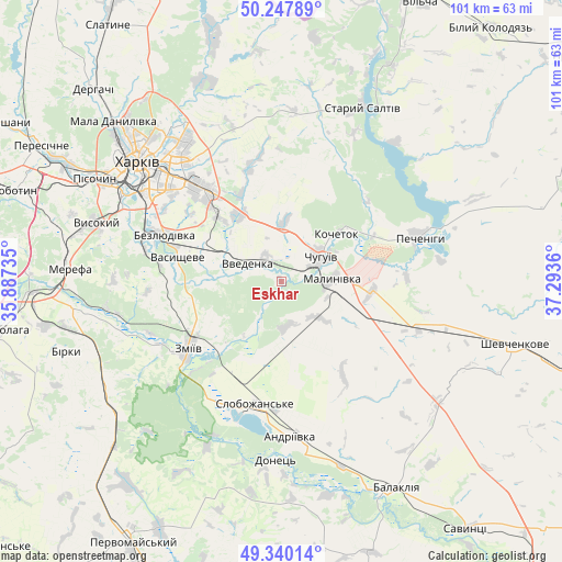
Eskhar GPS coordinates[2]
49° 47' 46.104" North, 36° 35' 25.692" East
| Map corner | latitude | longitude |
|---|---|---|
| Upper-left | 50.24789°, | 35.88735° |
| Center: | 49.79614°, | 36.59047° |
| Lower-right: | 49.34014°, | 37.2936° |
| Map W x H: | 100.9×100.9 km | = 62.7×62.7mi |
| max Lat: | 52.18903° ⇑20.5% North |
| Eskhar: | 49.79614° |
| min Lat: | ⇓79.5% South 44.39214° |
| min Long | Eskhar | max Long |
| 22.20555° | 36.59047° | 40.13222° |
| W 90%⇐ | ⇒10% E |
Elevation
Elevation of Eskhar is 120 m = 394 ft, and this is 35.8 m = 117 ft below average elevation for this country.
| Max E: |
886 m = 2907 ft | 54.9% |
| Avg. | 155.8 m = 511 ft | |
| Eskhar | 120 m = 394 ft | |
Min E: |
-3 m = -10 ft | 45.1% |
See also: Ukraine elevation on elevation.city.
Geographical zone
Eskhar is located in North temperate zone (between Tropic of Cancer and the Arctic Circle). Distance of this North polar circle is 1864.4 km =1158.5 mi to North.| Distance of | km | miles | from Eskhar |
|---|---|---|---|
| North Pole | 4470.3 | 2777.7 | to North |
| Arctic Circle | 1864.4 | 1158.5 | to North |
| Tropic Cancer | 2930.9 | 1821.2 | to South |
| Equator | 5536.8 | 3440.4 | to South |


Nearby cities:
15 places around Eskhar: (largest is in red/bold)
• Bezlyudivka
24.9 km =15.5 mi,  290°
290°
• Chuhuyiv
8.3 km =5.2 mi,  57°
57°
• Kharkiv
31.7 km =19.7 mi,  310°
310°
• Khorosheve
27.6 km =17.1 mi,  283°
283°
• Kochetok
14.1 km =8.8 mi,  48°
48°
• Kulynychi
25.4 km =15.8 mi,  324°
324°
• Lyman
23.7 km =14.7 mi,  201°
201°
• Malynivka
10.5 km =6.5 mi,  77°
77°
• Novopokrovka
5.2 km =3.2 mi, 323°
• Pechenihy
26.1 km =16.2 mi,  71°
71°
• Pokotylivka
32.5 km =20.2 mi, 293°
• Slobozhans’ke
22.6 km =14 mi,  191°
191°
• Vasyshcheve
19.3 km =12 mi, 280°
• Vvedenka
7 km =4.3 mi,  295°
295°
• Zmiyiv
22.1 km =13.7 mi,  232°
232°
Sources, notices
• [Note1] Compared only with cities in Ukraine existing in our database
• [Src1] Map data: © OpenStreetMap contributors (CC-BY-SA)
• [Src2] Other city data from geonames.org with taken over terms of usage.
• [Src3] Geographical zone / Annual Mean Temperature by Robert A. Rohde @ Wikipedia
