Slobozhans’ke geodata
Slobozhans’ke (Kharkiv) is a populated place; located in Ukraine in Europe/Kiev (GMT+3) time zone. With population of 15,825 people, there are 247 cities with bigger population in this country. Compared to other cities in Ukraine, 76.2% of cities are located further ↓South; 89.8% of cities are located further ←West and 62.4% of cities have higher elevation than Slobozhans’ke. Note1


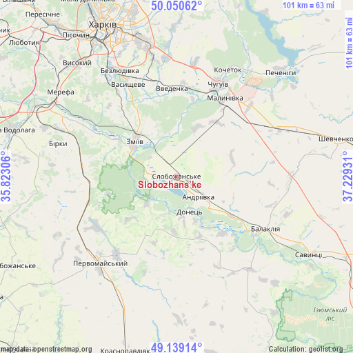
Slobozhans’ke GPS coordinates[2]
49° 35' 49.236" North, 36° 31' 34.248" East
| Map corner | latitude | longitude |
|---|---|---|
| Upper-left | 50.05062°, | 35.82306° |
| Center: | 49.59701°, | 36.52618° |
| Lower-right: | 49.13914°, | 37.22931° |
| Map W x H: | 101.3×101.3 km | = 62.9×62.9mi |
| max Lat: | 52.18903° ⇑23.8% North |
| Slobozhans’ke: | 49.59701° |
| min Lat: | ⇓76.2% South 44.39214° |
| min Long | Slobozhans’ke | max Long |
| 22.20555° | 36.52618° | 40.13222° |
| W 89.8%⇐ | ⇒10.2% E |
Elevation
Elevation of Slobozhans’ke is 99 m = 325 ft, and this is 56.8 m = 186 ft below average elevation for this country.
| Max E: |
886 m = 2907 ft | 62.4% |
| Avg. | 155.8 m = 511 ft | |
| Slobozhans’ke | 99 m = 325 ft | |
Min E: |
-3 m = -10 ft | 37.6% |
See also: Ukraine elevation on elevation.city.
Geographical zone
Slobozhans’ke is located in North temperate zone (between Tropic of Cancer and the Arctic Circle). Distance of this North polar circle is 1886.5 km =1172.2 mi to North.| Distance of | km | miles | from Slobozhans’ke |
|---|---|---|---|
| North Pole | 4492.4 | 2791.4 | to North |
| Arctic Circle | 1886.5 | 1172.2 | to North |
| Tropic Cancer | 2908.8 | 1807.4 | to South |
| Equator | 5514.7 | 3426.7 | to South |


Nearby cities:
15 places around Slobozhans’ke: (largest is in red/bold)
• Balakliya
28.3 km =17.6 mi,  121°
121°
• Bezlyudivka
36.2 km =22.5 mi,  328°
328°
• Chuhuyiv
29 km =18 mi,  23°
23°
• Eskhar
22.6 km =14 mi,  11°
11°
• Khorosheve
36.2 km =22.5 mi,  322°
322°
• Kochetok
34.9 km =21.7 mi,  25°
25°
• Lyman
4 km =2.5 mi,  271°
271°
• Malynivka
28.6 km =17.8 mi, 31°
• Novopokrovka
26.3 km =16.3 mi,  3°
3°
• Pechenihy
42.4 km =26.3 mi,  43°
43°
• Pervomays’kyy
32.4 km =20.1 mi,  223°
223°
• Utkivka
38.6 km =24 mi,  302°
302°
• Vasyshcheve
29.5 km =18.3 mi, 330°
• Vvedenka
25.3 km =15.7 mi,  356°
356°
• Zmiyiv
15.5 km =9.6 mi, 303°
In other languages:
- In France: Slobojanske
- In German: Sloboschanske
- In Russian: Komsomol’skoye, Слобожанское
- In Chinese: 科姆索莫利西克
Sources, notices
• [Note1] Compared only with cities in Ukraine existing in our database
• [Src1] Map data: © OpenStreetMap contributors (CC-BY-SA)
• [Src2] Other city data from geonames.org with taken over terms of usage.
• [Src3] Geographical zone / Annual Mean Temperature by Robert A. Rohde @ Wikipedia
