Zarech’ye geodata
Zarech’ye (Republic of Crimea) is a populated place; located in Ukraine in Europe/Simferopol (GMT+3) time zone. With population of 779 people, there are 1499 cities with bigger population in this country. Compared to other cities in Ukraine, 81.1% of cities are located further ↑North; 76.5% of cities are located further ←West and 81% of cities have higher elevation than Zarech’ye. Note1
Administrative division(s):
- Level 1: Republic of Crimea
- Level 2: Nizhnegorskiy rayon
- Level 3: Ivanovskoye sel'skoye poselenye


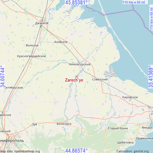
Zarech’ye GPS coordinates[2]
45° 21' 42.948" North, 34° 42' 38.016" East
| Map corner | latitude | longitude |
|---|---|---|
| Upper-left | 45.85381°, | 34.00744° |
| Center: | 45.36193°, | 34.71056° |
| Lower-right: | 44.86574°, | 35.41369° |
| Map W x H: | 109.9×109.9 km | = 68.3×68.3mi |
| max Lat: | 52.18903° ⇑81.1% North |
| Zarech’ye: | 45.36193° |
| min Lat: | ⇓18.9% South 44.39214° |
| min Long | Zarech’ye | max Long |
| 22.20555° | 34.71056° | 40.13222° |
| W 76.5%⇐ | ⇒23.5% E |
Elevation
Elevation of Zarech’ye is 40 m = 131 ft, and this is 115.8 m = 380 ft below average elevation for this country.
| Max E: |
886 m = 2907 ft | 81% |
| Avg. | 155.8 m = 511 ft | |
| Zarech’ye | 40 m = 131 ft | |
Min E: |
-3 m = -10 ft | 19% |
See also: Ukraine elevation on elevation.city.
Geographical zone
Zarech’ye is located in North temperate zone (between Tropic of Cancer and the Arctic Circle). Distance of this North polar circle is 2357.4 km =1464.8 mi to North.| Distance of | km | miles | from Zarech’ye |
|---|---|---|---|
| North Pole | 4963.3 | 3084.1 | to North |
| Arctic Circle | 2357.4 | 1464.8 | to North |
| Tropic Cancer | 2437.9 | 1514.8 | to South |
| Equator | 5043.8 | 3134.1 | to South |


Nearby cities:
15 places around Zarech’ye: (largest is in red/bold)
• Chernozemnoye
10 km =6.2 mi,  58°
58°
• Drofino
11.2 km =7 mi,  221°
221°
• Frunze
6.9 km =4.3 mi,  180°
180°
• Ivanovka
1.6 km =1 mi,  28°
28°
• Kostochkovka
5.7 km =3.5 mi,  209°
209°
• Lomonosovo
4.9 km =3 mi,  334°
334°
• Mitrofanovka
10.2 km =6.3 mi,  345°
345°
• Nizhnegorskiy
9.8 km =6.1 mi,  12°
12°
• Pchel’niki
9.4 km =5.8 mi,  142°
142°
• Plodovoye
9.8 km =6.1 mi,  4°
4°
• Razlivy
11 km =6.8 mi, 3°
• Sadovoye
7.3 km =4.5 mi, 218°
• Zavetnoye
8.6 km =5.3 mi,  116°
116°
• Zhelyabovka
5.5 km =3.4 mi,  41°
41°
• Zhemchuzhina
10.5 km =6.5 mi,  203°
203°
Sources, notices
• [Note1] Compared only with cities in Ukraine existing in our database
• [Src1] Map data: © OpenStreetMap contributors (CC-BY-SA)
• [Src2] Other city data from geonames.org with taken over terms of usage.
• [Src3] Geographical zone / Annual Mean Temperature by Robert A. Rohde @ Wikipedia
