Volodymyrets’ geodata
Volodymyrets’ (Rivne) is a seat of a second-order administrative division; located in Ukraine in Europe/Kiev (GMT+3) time zone. With population of 8,537 people, there are 416 cities with bigger population in this country. Compared to other cities in Ukraine, 97.8% of cities are located further ↓South; 80.6% of cities are located further →East and 60.6% of cities have lower elevation than Volodymyrets’. Note1


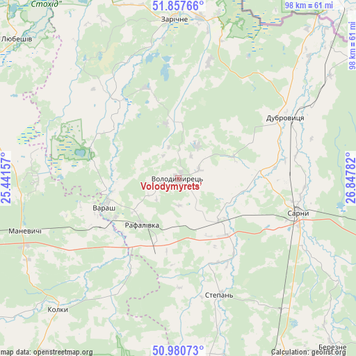
Volodymyrets’ GPS coordinates[2]
51° 25' 16.68" North, 26° 8' 40.884" East
| Map corner | latitude | longitude |
|---|---|---|
| Upper-left | 51.85766°, | 25.44157° |
| Center: | 51.4213°, | 26.14469° |
| Lower-right: | 50.98073°, | 26.84782° |
| Map W x H: | 97.5×97.5 km | = 60.6×60.6mi |
| max Lat: | 52.18903° ⇑2.2% North |
| Volodymyrets’: | 51.4213° |
| min Lat: | ⇓97.8% South 44.39214° |
| min Long | Volodymyrets’ | max Long |
| 22.20555° | 26.14469° | 40.13222° |
| W 19.4%⇐ | ⇒80.6% E |
Elevation
Elevation of Volodymyrets’ is 170 m = 558 ft, and this is 14.2 m = 47 ft above average elevation for this country.
| Max E: |
886 m = 2907 ft | 39.4% |
| Volodymyrets’ | 170 m 558 ft | |
| Avg. | 155.8 m = 511 ft | |
Min E: |
-3 m = -10 ft | 60.6% |
See also: Ukraine elevation on elevation.city.
Geographical zone
Volodymyrets’ is located in North temperate zone (between Tropic of Cancer and the Arctic Circle). Distance of this North polar circle is 1683.7 km =1046.2 mi to North.| Distance of | km | miles | from Volodymyrets’ |
|---|---|---|---|
| North Pole | 4289.5 | 2665.4 | to North |
| Arctic Circle | 1683.7 | 1046.2 | to North |
| Tropic Cancer | 3111.6 | 1933.5 | to South |
| Equator | 5717.5 | 3552.7 | to South |


Nearby cities:
15 places around Volodymyrets’: (largest is in red/bold)
• Berezne
63 km =39.1 mi,  137°
137°
• Dubrovytsya
33.7 km =20.9 mi,  59°
59°
• Kivertsi
81 km =50.3 mi,  216°
216°
• Klevan
76.3 km =47.4 mi,  188°
188°
• Kostopil’
64.1 km =39.8 mi,  160°
160°
• Lukiv
66.1 km =41.1 mi,  231°
231°
• Lyubeshiv
58 km =36 mi,  311°
311°
• Manevychi
44.7 km =27.8 mi,  251°
251°
• Olyka
81.5 km =50.6 mi,  196°
196°
• Orzhiv
69.1 km =42.9 mi,  181°
181°
• Rokytne
75.9 km =47.2 mi,  101°
101°
• Rozhyshche
83 km =51.6 mi, 227°
• Sarny
33.1 km =20.6 mi,  106°
106°
• Varash
22.1 km =13.7 mi, 249°
• Zarichne
43.5 km =27 mi,  358°
358°
Sources, notices
• [Note1] Compared only with cities in Ukraine existing in our database
• [Src1] Map data: © OpenStreetMap contributors (CC-BY-SA)
• [Src2] Other city data from geonames.org with taken over terms of usage.
• [Src3] Geographical zone / Annual Mean Temperature by Robert A. Rohde @ Wikipedia
