Kivertsi geodata
Kivertsi (Volyn) is a seat of a second-order administrative division; located in Ukraine in Europe/Kiev (GMT+3) time zone. With population of 16,509 people, there are 232 cities with bigger population in this country. Compared to other cities in Ukraine, 94.8% of cities are located further ↓South; 83.8% of cities are located further →East and 68.2% of cities have lower elevation than Kivertsi. Note1


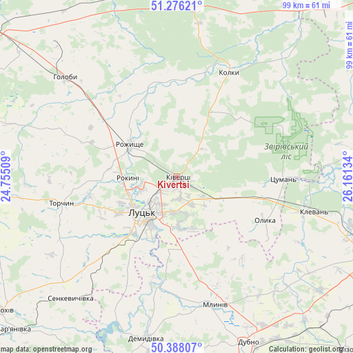
Kivertsi GPS coordinates[2]
50° 50' 3.3" North, 25° 27' 29.556" East
| Map corner | latitude | longitude |
|---|---|---|
| Upper-left | 51.27621°, | 24.75509° |
| Center: | 50.83425°, | 25.45821° |
| Lower-right: | 50.38807°, | 26.16134° |
| Map W x H: | 98.8×98.8 km | = 61.4×61.4mi |
| max Lat: | 52.18903° ⇑5.2% North |
| Kivertsi: | 50.83425° |
| min Lat: | ⇓94.8% South 44.39214° |
| min Long | Kivertsi | max Long |
| 22.20555° | 25.45821° | 40.13222° |
| W 16.2%⇐ | ⇒83.8% E |
Elevation
Elevation of Kivertsi is 199 m = 653 ft, and this is 43.2 m = 142 ft above average elevation for this country.
| Max E: |
886 m = 2907 ft | 31.8% |
| Kivertsi | 199 m 653 ft | |
| Avg. | 155.8 m = 511 ft | |
Min E: |
-3 m = -10 ft | 68.2% |
See also: Ukraine elevation on elevation.city.
Geographical zone
Kivertsi is located in North temperate zone (between Tropic of Cancer and the Arctic Circle). Distance of this North polar circle is 1748.9 km =1086.7 mi to North.| Distance of | km | miles | from Kivertsi |
|---|---|---|---|
| North Pole | 4354.8 | 2705.9 | to North |
| Arctic Circle | 1748.9 | 1086.7 | to North |
| Tropic Cancer | 3046.3 | 1892.9 | to South |
| Equator | 5652.2 | 3512.1 | to South |


Nearby cities:
15 places around Kivertsi: (largest is in red/bold)
• Berestechko
58.1 km =36.1 mi,  204°
204°
• Demydivka
46 km =28.6 mi,  190°
190°
• Dubno
50.3 km =31.3 mi,  157°
157°
• Hołoby
42.2 km =26.2 mi,  311°
311°
• Klevan
37.8 km =23.5 mi,  105°
105°
• Lokachi
57.9 km =36 mi,  259°
259°
• Lukiv
24.6 km =15.3 mi,  350°
350°
• Lutsk
11.6 km =7.2 mi,  224°
224°
• Manevychi
51.4 km =31.9 mi,  5°
5°
• Mlyniv
37.9 km =23.5 mi, 162°
• Olyka
28 km =17.4 mi,  117°
117°
• Orzhiv
46.6 km =29 mi,  94°
94°
• Rozhyshche
16 km =9.9 mi,  304°
304°
• Tarakaniv
53.5 km =33.2 mi, 160°
• Tynne
57.3 km =35.6 mi, 116°
Sources, notices
• [Note1] Compared only with cities in Ukraine existing in our database
• [Src1] Map data: © OpenStreetMap contributors (CC-BY-SA)
• [Src2] Other city data from geonames.org with taken over terms of usage.
• [Src3] Geographical zone / Annual Mean Temperature by Robert A. Rohde @ Wikipedia
