Rokytne geodata
Rokytne (Rivne) is a seat of a second-order administrative division; located in Ukraine in Europe/Kiev (GMT+3) time zone. With population of 11,726 people, there are 313 cities with bigger population in this country. Compared to other cities in Ukraine, 97.2% of cities are located further ↓South; 77.6% of cities are located further →East and 61.6% of cities have lower elevation than Rokytne. Note1


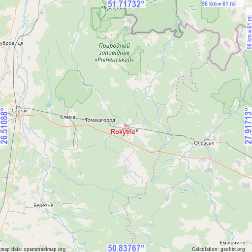
Rokytne GPS coordinates[2]
51° 16' 46.56" North, 27° 12' 50.4" East
| Map corner | latitude | longitude |
|---|---|---|
| Upper-left | 51.71732°, | 26.51088° |
| Center: | 51.2796°, | 27.214° |
| Lower-right: | 50.83767°, | 27.91713° |
| Map W x H: | 97.8×97.8 km | = 60.8×60.8mi |
| max Lat: | 52.18903° ⇑2.8% North |
| Rokytne: | 51.2796° |
| min Lat: | ⇓97.2% South 44.39214° |
| min Long | Rokytne | max Long |
| 22.20555° | 27.214° | 40.13222° |
| W 22.4%⇐ | ⇒77.6% E |
Elevation
Elevation of Rokytne is 174 m = 571 ft, and this is 18.2 m = 60 ft above average elevation for this country.
| Max E: |
886 m = 2907 ft | 38.4% |
| Rokytne | 174 m 571 ft | |
| Avg. | 155.8 m = 511 ft | |
Min E: |
-3 m = -10 ft | 61.6% |
See also: Ukraine elevation on elevation.city.
Geographical zone
Rokytne is located in North temperate zone (between Tropic of Cancer and the Arctic Circle). Distance of this North polar circle is 1699.4 km =1056 mi to North.| Distance of | km | miles | from Rokytne |
|---|---|---|---|
| North Pole | 4305.3 | 2675.2 | to North |
| Arctic Circle | 1699.4 | 1056 | to North |
| Tropic Cancer | 3095.8 | 1923.6 | to South |
| Equator | 5701.8 | 3542.9 | to South |


Nearby cities:
15 places around Rokytne: (largest is in red/bold)
• Berezne
44.8 km =27.8 mi,  226°
226°
• Buchmany
62.3 km =38.7 mi,  112°
112°
• Druzhba
53.9 km =33.5 mi,  100°
100°
• Dubrovytsya
55.7 km =34.6 mi,  306°
306°
• Horodnytsya
53 km =32.9 mi,  172°
172°
• Hubkiv
51.6 km =32.1 mi,  193°
193°
• Koloniya Zastav’ye
53 km =32.9 mi, 193°
• Korets
73.8 km =45.9 mi,  182°
182°
• Kostopil’
69.5 km =43.2 mi, 230°
• Novi Bilokorovychi
61.3 km =38.1 mi, 107°
• Olevs’k
31.1 km =19.3 mi, 101°
• Sarny
43 km =26.7 mi,  278°
278°
• Velyki Mezhyrichi
73.7 km =45.8 mi,  199°
199°
• Volodymyrets’
75.9 km =47.2 mi, 281°
• Yemil’chyne
61.2 km =38 mi,  137°
137°
Sources, notices
• [Note1] Compared only with cities in Ukraine existing in our database
• [Src1] Map data: © OpenStreetMap contributors (CC-BY-SA)
• [Src2] Other city data from geonames.org with taken over terms of usage.
• [Src3] Geographical zone / Annual Mean Temperature by Robert A. Rohde @ Wikipedia
