Lukiv geodata
Lukiv (Volyn) is a populated place; located in Ukraine in Europe/Kiev (GMT+3) time zone. With population of 3,043 people, there are 931 cities with bigger population in this country. Compared to other cities in Ukraine, 95.9% of cities are located further ↓South; 84.1% of cities are located further →East and 62.3% of cities have lower elevation than Lukiv. Note1


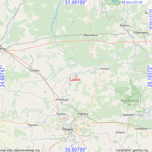
Lukiv GPS coordinates[2]
51° 3' 7.56" North, 25° 24' 2.124" East
| Map corner | latitude | longitude |
|---|---|---|
| Upper-left | 51.49199°, | 24.69747° |
| Center: | 51.0521°, | 25.40059° |
| Lower-right: | 50.60799°, | 26.10372° |
| Map W x H: | 98.3×98.3 km | = 61.1×61.1mi |
| max Lat: | 52.18903° ⇑4.1% North |
| Lukiv: | 51.0521° |
| min Lat: | ⇓95.9% South 44.39214° |
| min Long | Lukiv | max Long |
| 22.20555° | 25.40059° | 40.13222° |
| W 15.9%⇐ | ⇒84.1% E |
Elevation
Elevation of Lukiv is 177 m = 581 ft, and this is 21.2 m = 70 ft above average elevation for this country.
| Max E: |
886 m = 2907 ft | 37.7% |
| Lukiv | 177 m 581 ft | |
| Avg. | 155.8 m = 511 ft | |
Min E: |
-3 m = -10 ft | 62.3% |
See also: Ukraine elevation on elevation.city.
Geographical zone
Lukiv is located in North temperate zone (between Tropic of Cancer and the Arctic Circle). Distance of this North polar circle is 1724.7 km =1071.7 mi to North.| Distance of | km | miles | from Lukiv |
|---|---|---|---|
| North Pole | 4330.6 | 2690.9 | to North |
| Arctic Circle | 1724.7 | 1071.7 | to North |
| Tropic Cancer | 3070.5 | 1907.9 | to South |
| Equator | 5676.5 | 3527.2 | to South |


Nearby cities:
15 places around Lukiv: (largest is in red/bold)
• Hołoby
27.7 km =17.2 mi,  277°
277°
• Kivertsi
24.6 km =15.3 mi,  170°
170°
• Klevan
53 km =32.9 mi,  130°
130°
• Kovel
51.6 km =32.1 mi,  290°
290°
• Lokachi
63.3 km =39.3 mi,  236°
236°
• Lutsk
32.8 km =20.4 mi,  187°
187°
• Manevychi
28.5 km =17.7 mi,  19°
19°
• Mlyniv
62.3 km =38.7 mi, 165°
• Nuyno
64.7 km =40.2 mi,  328°
328°
• Olyka
47 km =29.2 mi,  142°
142°
• Orzhiv
57.7 km =35.9 mi,  119°
119°
• Rozhyshche
17.8 km =11.1 mi,  211°
211°
• Turiys’k
61.4 km =38.2 mi,  273°
273°
• Varash
45.5 km =28.3 mi,  43°
43°
• Volodymyrets’
66.1 km =41.1 mi,  51°
51°
Sources, notices
• [Note1] Compared only with cities in Ukraine existing in our database
• [Src1] Map data: © OpenStreetMap contributors (CC-BY-SA)
• [Src2] Other city data from geonames.org with taken over terms of usage.
• [Src3] Geographical zone / Annual Mean Temperature by Robert A. Rohde @ Wikipedia
