Vinnytsia geodata
Vinnytsia (Vinnyts'ka) is a seat of a first-order administrative division; located in Ukraine in Europe/Kiev (GMT+3) time zone. With population of 352,115 people, there are 14 cities with bigger population in this country. Compared to other cities in Ukraine, 70.3% of cities are located further ↓South; 74.8% of cities are located further →East and 77.2% of cities have lower elevation than Vinnytsia. Note1


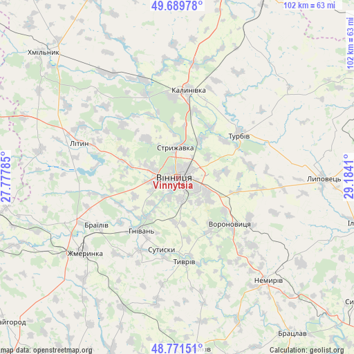
Vinnytsia GPS coordinates[2]
49° 13' 58.008" North, 28° 28' 51.492" East
| Map corner | latitude | longitude |
|---|---|---|
| Upper-left | 49.68978°, | 27.77785° |
| Center: | 49.23278°, | 28.48097° |
| Lower-right: | 48.77151°, | 29.1841° |
| Map W x H: | 102.1×102.1 km | = 63.4×63.4mi |
| max Lat: | 52.18903° ⇑29.7% North |
| Vinnytsia: | 49.23278° |
| min Lat: | ⇓70.3% South 44.39214° |
| min Long | Vinnytsia | max Long |
| 22.20555° | 28.48097° | 40.13222° |
| W 25.2%⇐ | ⇒74.8% E |
Elevation
Elevation of Vinnytsia is 235 m = 771 ft, and this is 79.2 m = 260 ft above average elevation for this country.
| Max E: |
886 m = 2907 ft | 22.8% |
| Vinnytsia | 235 m 771 ft | |
| Avg. | 155.8 m = 511 ft | |
Min E: |
-3 m = -10 ft | 77.2% |
See also: Vinnytsia elevation on elevation.city.
Geographical zone
Vinnytsia is located in North temperate zone (between Tropic of Cancer and the Arctic Circle). Distance of this North polar circle is 1927 km =1197.4 mi to North.| Distance of | km | miles | from Vinnytsia |
|---|---|---|---|
| North Pole | 4532.9 | 2816.6 | to North |
| Arctic Circle | 1927 | 1197.4 | to North |
| Tropic Cancer | 2868.3 | 1782.3 | to South |
| Equator | 5474.2 | 3401.5 | to South |


Nearby cities:
15 places around Vinnytsia: (largest is in red/bold)
• Brailiv
26.1 km =16.2 mi,  238°
238°
• Kalynivka
24.8 km =15.4 mi,  7°
7°
• Khmilnyk
52.5 km =32.6 mi,  313°
313°
• Lityn
30.8 km =19.1 mi,  289°
289°
• Lypovets
41.7 km =25.9 mi,  90°
90°
• Murafa
55.2 km =34.3 mi,  200°
200°
• Nemyriv
39 km =24.2 mi,  138°
138°
• Nova Pryluka
22.4 km =13.9 mi,  45°
45°
• Pavlivka
23.3 km =14.5 mi,  356°
356°
• Sobolivka
16.8 km =10.4 mi, 47°
• Sutysky
21.7 km =13.5 mi,  192°
192°
• Turbiv
21.6 km =13.4 mi, 53°
• Tyvriv
24.4 km =15.2 mi,  175°
175°
• Voronovytsya
20 km =12.4 mi,  133°
133°
• Zhmerynka
34.6 km =21.5 mi,  230°
230°
Sources, notices
• [Note1] Compared only with cities in Ukraine existing in our database
• [Src1] Map data: © OpenStreetMap contributors (CC-BY-SA)
• [Src2] Other city data from geonames.org with taken over terms of usage.
• [Src3] Geographical zone / Annual Mean Temperature by Robert A. Rohde @ Wikipedia
